Cooperative foraging between dolphins and fish-eating killer whales
Using aerial drone and biologgers equipped with video, acoustic and inertial sensors, we recorded interactions between fish-eating northern resident killer whales (Orcinus orca) and Pacific white-sided dolphins (Lagenorhynchus obliquidens) in the presence of adult Chinook salmon (Oncorhynchus tshawytscha). We observed frequent co-occurrence and coordinated movements, with the killer whales orienting towards the dolphins and following them to depth. We also recorded reduced echolocation and rolling movements by the killer whales in the presence of dolphins, suggesting that the whales may eavesdrop on dolphin echolocations to scan broader areas to locate large Chinook salmon—prey that are too big for the dolphins to capture and swallow whole.
Fortune, S.M.E., Cheng, X., Holmes, K., Trites, A.W. (2025). Cooperative foraging between dolphins and fish-eating killer whales. Sci Rep 15, 42897. https://doi.org/10.1038/s41598-025-22718-4
Parasites of the hermit crab Pagurus hirsutiusculus; distribution, prevalence, and thermal ecology
Parasites are common throughout the biosphere and can play significant ecological roles. However, most parasites are understudied, particularly with regards to how their prevalence and impacts vary with environmental conditions. As a result, there remains an incomplete understanding of how both parasites and their hosts may be impacted by climate change. We conducted field surveys to better understand the parasite distributions of the intertidal hermit crab Pagurus hirsutiusculus in British Columbia.
Abbott, M.H., Harley, C.D.G., Martell, H.A., Janusson, C., Lemay, M.A., Gehman, A-L.M. (2025). Parasites of the hermit crab Pagurus hirsutiusculus; distribution, prevalence, and thermal ecology. PLoS One 20(11): e0335145. https://doi.org/10.1371/journal.pone.0335145
Marine heatwaves modulate food webs and carbon transport processes
Marine heatwave (MHW) impacts on ecosystem functions and services remain poorly constrained due to limited time-resolved datasets integrating physical, chemical, and biological parameters at relevant scales. Here we show that combining over a decade of autonomous Biogeochemical (BGC)-Argo float measurements with water-column plankton community profiles reveals the impacts of MHWs on particulate organic carbon (POC) production, transformation, and transport in the northeastern subarctic Pacific Ocean.
Bif, M.B., Kellogg, C.T.E., Huang, Y., Anstett, J., Traving, S., Pẽna, M.A., Hallam, S.J., Johnson, K.S. (2025). l. Marine heatwaves modulate food webs and carbon transport processes. Nat Commun 16, 8535. https://doi.org/10.1038/s41467-025-63605-w
Late Pleistocene vegetation and climate history of northern Vancouver Island, Canada: spatiotemporal variation in deglacial ecology along the Pacific margin of the Cordilleran Ice Sheet
Palaeoecological analysis of six cores on northern Vancouver Island, Canada, reveals asynchronous vegetation responses to climatic changes at the interface of the Cordilleran Ice Sheet and the Pacific Ocean during the terminal Pleistocene and earliest Holocene. Our results demonstrate the importance of understanding regional vegetation and climatic histories at coast-continent interfaces adjacent to major components of global climate such as the North Pacific Ocean when investigating the teleconnections of oceanic and atmospheric systems.
Hebda, C.F.G., Hebda, R.J., Fedje, D., Letham, B., Dyck, A., McLaren, D., (2025). Late Pleistocene vegetation and climate history of northern Vancouver Island, Canada: spatiotemporal variation in deglacial ecology along the Pacific margin of the Cordilleran Ice Sheet. Quarterly International, 747. https://doi.org/10.1016/j.quaint.2025.109955
New and interesting seaweed records from the Hakai area of the central coast of British Columbia: Phaeophyceae
After 13 years of intensive sampling of seaweeds in the Hakai area of the central coast of British Columbia, we report on our collection of 67 of the approximately 100 brown algal species expected in the area based on known distributions. A number of species are reported for the first time in the northeast Pacific: we identified Hecatonema terminale, based on efforts to sequence several host species of red algae, an undescribed species of Acinetosporaceae previously identified erroneously as Hincksia granulosa that still requires a name, and undescribed species of Pylaiella and Ectocarpus.
Lindstrom, S.C., Lemay, M.A., Janusson, C., Starko, S., Hind, K.R., Martone, P.T. (2025). New and interesting seaweed records from the Hakai area of the central coast of British Columbia: Phaeophyceae. Botany. 103: 1–24. https://doi.org/10.1139/cjb-2025-0003
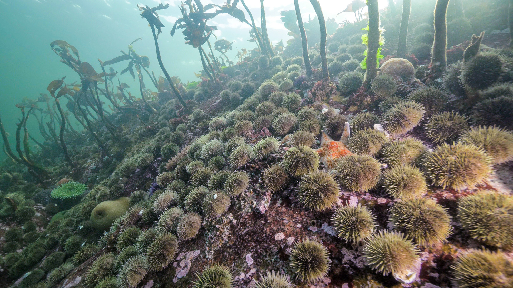
Thermal suppression of gametogenesis can explain historical collapses in larval recruitment in Strongylocentrotus purpuratus
Projections for population viability under climate change are often made using estimates of thermal lethal thresholds. These estimates vary across life history stages and can be valuable for explaining or forecasting shifts in population viability. For the urchin Strongylocentrotus purpuratus, larval supply is known to decline near the southern edge of the range during marine heatwaves despite temperatures remaining below temperatures thought to limit larval survival. We experimentally show that sublethal suppression of gametogenesis by marine heatwaves can partially explain these historical collapses in recruitment.
Okamoto, D.K., Spindel, N.B., Munstermann, M.J., Karelitz, S., Collicutt, B., Gimenez, I., Rolheiser, K. Cronmiller, E., Foss, M., Mahara, N., Swezey, D., Ferraro, R., Rogers-Bennett, L., Schroeter, S.C., (2025). Thermal suppression of gametogenesis can explain historical collapses in larval recruitment in Strongylocentrotus purpuratus. Commun Biol 8, 1490. https://doi.org/10.1038/s42003-025-08829-8
The coupled oxygen and carbon dynamics in the subsurface waters of the Gulf and Lower St. Lawrence Estuary and implications for artificial oxygenation
The Gulf and Lower St. Lawrence Estuary have experienced major environmental change over the past century, including the development of hypoxic bottom waters and their simultaneous warming and acidification. This study provides new long-term characterizations of deepwater dissolved oxygen and dissolved inorganic carbon cycling and offers a first-order assessment of the feasibility of large-scale re-oxygenation in the Gulf and Lower St. Lawrence Estuary.
Nesbitt, W. A., Stevens, S. W., Mucci, A. O., Gerke, L., Tanhua, T., Chaillou, G., and Wallace, D. W. R. (2025). The coupled oxygen and carbon dynamics in the subsurface waters of the Gulf and Lower St. Lawrence Estuary and implications for artificial oxygenation, Ocean Science., 21, 2179–2195. https://doi.org/10.5194/os-21-2179-2025
Cool ocean temperatures offer limited protection to a heat-stressed keystone predator during atmospheric heatwaves
The increasing frequency and intensity of extreme climatic events demands a better understanding of how organisms respond to temperature shifts and how these responses shape species interactions. Temperature-related disruptions in individual behaviour and physiology can signal broader community change. This is particularly true for keystone species, whose impact on their ecosystem is disproportionately large. We tested how periodic exposure to high air temperatures affects mortality, feeding, and metabolism in juvenile Pisaster ochraceus (ochre sea star), a keystone intertidal predator, by manipulating air and seawater temperatures representing typical and heatwave conditions in Barkley Sound, British Columbia, Canada.
Walton, L.N., Watts, V.R., Schuster, J.M., Bates, A.E. (2025). Cool ocean temperatures offer limited protection to a heat-stressed keystone predator during atmospheric heatwaves, Marine Ecology Progress Series 773:77–93. https://doi.org/10.3354/meps14980