Welcome to the second issue of the Tula Quarterly! In this issue we highlight the Tula Foundation’s many collaborations and initiatives:
Nick Viner talks about the hazards and rewards of surveying the surging waters of British Columbia’s Fraser Canyon.
TulaSalud’s Sareen Ali and her colleagues tackle the issue of unintended pregnancies in rural Guatemala.
Sarah Fortune and her team travel to Baffin Island, Nunavut, to track Arctic-dwelling bowhead whales—the longest-living whale species, surviving up to 200 years—to determine the effects of climate change on their food sources.
... and much more!
This issue’s cover by our resident illustrator and graphic designer Mercedes Minck is inspired by the “Follow the Water” story in this issue, which focuses on Hakai Institute ecosystem scientists and technicians, whose work extends from ice fields to oceans.
July 22, 2024
Riding the Edge in the Fraser Canyon
In the wake of the massive Big Bar landslide that threatened the survival of Fraser River salmon, the Hakai Institute’s geospatial team participated in a joint effort to complete the first-ever underwater mapping of British Columbia’s perilous Fraser Canyon.
High-velocity currents are common at the section of the Fraser Canyon known as Hell’s Gate, as shown in this image taken from the Hell’s Gate Airtram. Photo by D. Harvey
Nick Viner is a hydrographer—someone who maps the physical features of bodies of water, whether seafloor, lake bottom, or riverbed. Trained in marine geomatics, Viner worked on bathymetry surveys in the Gulf of Mexico before starting at the Hakai Institute in 2018.
Since then he’s mapped the northwest coast of Calvert Island, British Columbia, and performed aerial surveys with the Hakai Institute’s Airborne Coastal Observatory (ACO) as part of the institute’s geospatial team. In 2021, Viner stepped up as the chief hydrographer for a major multidisciplinary effort: mapping the underwater contours of the Fraser Canyon in British Columbia’s Fraser River.
A mecca for river rafting and the site of the Hell’s Gate Airtram, the Fraser Canyon is famous for steep cliffs and fast water. The canyon is a 375-kilometer stretch of the Fraser River that lies between Soda Creek and Yale. Despite some earlier attempts, no one had been able to successfully navigate this hazardous stretch of the river while deploying multibeam sonar.
Then came a reason to try again, in the form of a massive landslide. In June of 2019, authorities received reports of the slide, located near Big Bar, and learned that it appeared to be blocking the river to upstream salmon migration. As a 2024 report by geomorphologist and Simon Fraser University (SFU) environmental science professor Jeremy Venditti noted, “The landslide initiated one of the largest and most expensive emergency river restoration projects in the history of Canada.”
Will McInnes, left, and Nick Viner prepare for drone surveys. Photo by Derek Heathfield
A lead researcher with SFU’s River Dynamics Laboratory, which does vessel-based fieldwork on river systems and laboratory analyses of river flow dynamics, Venditti helped steer a multidisciplinary research effort to understand the nature of the event and its impacts on the ecosystem. As part of this effort, Hakai geospatial specialists—led by Derek Heathfield and supported by Will McInnes, among others—mobilized the ACO to gather LiDAR and other imagery of the Fraser Canyon.
Viner’s on-the-water work with multibeam sonar took the analysis deeper, literally. It was a tricky endeavor in a charging and turbulent river.
Ultimately, researchers determined that the slide occurred on November 1, 2018, several months before it was reported, and that it had deposited 84,000 cubic meters of rock in the river. That’s about the same volume as 7,500 cement trucks.
The Big Bar landslide jeopardized salmon populations in the upper Fraser basin, but this landslide is not unique—the chance of future slides in the Fraser Canyon is real, and past landslides have likely shaped current salmon biodiversity. The likelihood and impacts of these events on salmon remain uncertain. To improve our ability to respond to this and future events we undertook an investigation of past, present, and future impacts of landslides on Fraser salmon.
—Jeremy Venditti et al. Final Report: Landslide Impact on Flow Dynamics, Fish Migration and Genetics of Fraser River Salmon
A map shows the salmon species and the vast area of salmon habitat in the Fraser Basin that would be impacted by a landslide at Hell’s Gate—one of 13 sites the Fraser Canyon identified as posing a landslide risk. Map image by the Hakai Institute geospatial team
Buoyed by their success in 2021 mapping the Big Bar landslide, the following summer the team expanded its scope to a massive survey project to identify past landslides and future landslide risk zones in the Fraser Canyon. These factors could offer critical insights into the future of the river’s salmon populations.
Gathering and interpreting the data involved dozens of university and government researchers, technicians, First Nations, and other experts, including local “technical water services” company Rivertec that safely guided the researchers in their pontoon boats.
After several weeks of surveys followed by analysis, the team discovered—in large part thanks to Viner’s deft hand with multibeam sonar and the expertise of Rivertec’s guides—that there have been 270 significant landslide events in the Fraser Canyon since the retreat of glaciers 12,000 years ago. They also identified 13 “sites of concern” where future landslides could block the path of migrating salmon.
In an interview with Tula Quarterly, Nick Viner explains a bit about the technology he employed and some of his experiences on the river.
Survey vessels, fitted with multibeam sonar and an acoustic Doppler current profiler, await their next mission in the Fraser Canyon. Photo by Nick Viner
Can you explain multibeam sonar in not-too-technical terms?
Long story short, it uses sound to map the seafloor or riverbed and reveal physical features underwater. It sends out a large swath of sound that travels through the water column, hits the bottom, and then is reflected back to a number of small receivers or listening devices. It’s doing this many, many times per second. Using this basic property of sound in water, it’s able to calculate these positions multiple times per second to generate a 3D model of the seafloor or riverbed.
It’s a somewhat simple concept, but the way it’s executed, and how fast it’s being executed—the sheer number of times it can send and receive the signal—makes it a pretty phenomenal piece of technology.
What made the project particularly challenging and memorable?
There were a lot of things, but one of the most basic is just the element of control. A multibeam sonar unit is a very pricey piece of equipment. And so when you’re using it, you’re always very cognizant of keeping it from getting damaged. You want to know how much water is below you, and the conditions of the water and the seafloor. You want to minimize the risks.
When you’re out on the ocean, you have a lot of control over your location and the water depth. If you need to stop, you can stop; if you need to go, you can go. I’d say 99.9 percent of surveying is in those sorts of environments. But even rivers like the Mississippi, which I’ve surveyed before, don’t compare to what we were doing in the Fraser Canyon.
Drone image of a survey vessel just downstream of the Big Bar landslide site. Photo by Derek Heathfield and Will McInnes
You mean you were out of control?
There’s a reason no one’s really surveyed this section of the Fraser River before. It’s wild. We were working in constricted canyons with whitewater rapids and flows that are so fast and so high that the amount that you can steer the boat and control it becomes super limited. You have to quickly adjust to that new environment. Everything I knew about planning a survey had to just be thrown out the window and we had to develop new methods on the fly.
Were there any particular moments where you felt you were riding the edge in terms of your equipment or safety?
Typically in the past I had done surveys in depths anywhere from 10 meters to, in the Gulf of Mexico, over 2,500 meters. At Big Bar we were above the slide, and there’s also these big sandbars, and so the depth shallows out really quick. I remember a point where we were coming down the river and the depth below the echo sounder got to something like 20 centimeters. And I was thinking, Oh, we shouldn’t be here. But it’s not like you can just stop and turn around—you have to work with the river. But it never got below 20 centimeters, thankfully.
We all knew the risks, and we had everyone’s blessing to do what we were doing. There was this collective agreement that we could lose this equipment. Everyone was pretty realistic about the task that we were about to perform and how, for lack of a better term, crazy it was.
The survey team and the Rivertec team at Big Bar, with Nick Viner on the far left. Photo by Will McInnes
You mentioned that Rivertec was a big help.
Definitely. They run the boats and they’ve been working on this river for decades. Having them there was a huge, huge help. In most places I have data on depths—I know how deep it is, mostly. But on these surveys I had no real data on depths, and so I had to rely on local knowledge.
That was especially true in Big Bar, where there are these big spires of rock. Some of them stick up above the water and you can see them. But they also exist just below water and if you don’t know the river you don’t really know where they are and they can really do some damage.
I would sit down with Rivertec and try to plan how to get the data we needed. They’d say, “Okay, so we can run in this direction, then we’ll pull the gear up and we’ll rip back up.” There were so many hazards that needed to be worked around, but being on the river with Rivertec was just a phenomenal experience. I can’t really put it into words.
Tula and the Hakai Institute were part of a wide array of partners providing expertise and/or funding for this project. Collaborators included: Fisheries and Oceans Canada (DFO); the British Columbia government; the British Columbia Salmon Restoration and Innovation Fund; researchers in a variety of fields from Simon Fraser University, the University of British Columbia, the University of Victoria, the University of Northern British Columbia, and others; and First Nations representatives from the Nlaka’pamux Nation, High Bar First Nation, and Boothroyd First Nation; the Fraser Basin Council; Rivertec; and Northwest Hydraulic Consultants.
To learn more about remediation of the Big Bar landslide under the auspices of the federal and provincial governments and local First Nations, see this DFO page.
July 12, 2024 | Originally published at TulaHealth
“Something So Crucial”
A new TulaSalud initiative aimed at Guatemalan girls and young women tackles the challenging issues of sexual health and reproductive rights.
Young women walk home from school on a street in Cobán in the department of Alta Verapaz, Guatemala. Rates of unintended pregnancy between girls aged 10 to 19 remain stubbornly high in Guatemala, particularly in rural areas. Photo by Kristina Blanchflower
In 2023, Guatemalan health officials recorded more than 62,000 pregnancies in girls and women aged 10 to 19. These reported numbers—which are likely considerably lower than the actual reality—are a stark reminder of the challenges young women face in many countries where attention to sexual and reproductive health and rights (SRHR) is underfunded or underemphasized.
“Most countries have made progress in the past 30 years in terms of maternal mortality rates for women 20 and above,” says TulaSalud president Christy Gombay. “But in most of the world, the level of adolescent pregnancies, and deaths related to these pregnancies, has remained relatively unchanged.”
From left, TulaSalud’s program coordinator Stuart Davidson, TulaSalud health and gender equity specialist Sareen Ali, and TulaSalud manager of digital health Estela Cojoc Suram meet with frontline health workers in the village of Aldea San Luis Tontem in the department of Alta Verapaz. Photo courtesy of TulaSalud
In coordination with Guatemala’s Ministry of Health, TulaSalud is launching a new program to address these issues. Called Empowering Indigenous Adolescents and Women for Equitable SRHR, the aim is to reduce adolescent pregnancies and maternal mortality among the country’s Indigenous population.
“It’s a very long name,” laughs Sareen Ali, TulaSalud’s health and gender equity specialist. “But in essence what we are trying to do is something so crucial, which is to empower women and girls in marginalized Indigenous communities to make informed decisions about their sexual and reproductive health and rights.”
The five-year program, which focuses on Indigenous populations in Guatemala’s Western Highlands, will be largely funded by Global Affairs Canada. In 2019, the Canadian government made a 10-year commitment to support the health of women, children, and adolescents around the world—with the intention of spending CAN $1.4-billion on average annually by 2023. Of this funding, $700-million per year is dedicated to SRHR.
The people of Guatemala live in a varied landscape encompassing several different biomes, from tropical rainforest to savanna. This valley near San Jerónimo in the department of Baja Verapaz shows a mix of dry scrub and montane forest. Photo by Kristina Blanchflower
Ali was born in India and raised in South Africa. She trained and practiced as a medical doctor in Port Elizabeth, South Africa, before moving to Canada, where she completed her masters degree in global health at McMaster University in Ontario. Along the way, Ali has seen firsthand the need for SRHR education and empowerment.
“When you work as a physician, you develop very close relationships with your patients, and you are aware of the barriers and challenges that they face when accessing healthcare services,” says Ali. “The reason I’m so passionate about this project comes from having had that personal experience with health inequity, along with a deep interest in how gender plays into it.”
The program will work to educate frontline health workers on SRHR approaches to get better outcomes for the well-being of women and girls, and provide access to reproductive health resources, contraceptives, and counseling via the advent of adolescent-friendly spaces currently being developed by the Guatemalan government.
Tula Salud’s executive director Isabel Lobos, left, and Christy Gombay, TulaSalud president, listen at a meeting in Cobán, the capital of Alta Verapaz. Photo by Kristina Blanchflower
Isabel Lobos, executive director of TulaSalud, notes that in general, Guatemala has “a population pyramid with a wide base” of young people: children, adolescents, and people under 30 make up more than one-third of the population. In rural and Indigenous regions of the country, however, the proportion of the under-30 cohort is even greater and makes almost 60 percent of the population.
“The needs and problems of young people historically have not been adequately addressed by the state,” says Lobos. “As a result the country currently faces serious consequences, among them a lack of education and development opportunities, violence, migration, irregular pregnancy, early pregnancies, and emerging diseases.”
Tele-education manager Magdalena Juarez working on her laptop at the TulaSalud offices in Cobán, joined by Lobos, center, and Gabriela Mancilla, a nursing instructor. Photo by Kristina Blanchflower
TulaSalud’s long history of partnerships in the country dates back to 2003, and includes not only Guatemala’s national and regional health authorities, but also UNICEF and the Pan American Health Organization. These roots will strengthen the SRHR work, as will Kawok, a digital health information system developed by TulaSalud. Kawok allows community health workers, nurses, doctors, and others to access patient health information, even in remote rural areas.
“There is a very real need in Guatemala for a project like this,” says Ali. “Our previous experience working in this context, and the very strong collaborations that we have with local partners—I think these are really going to facilitate the vision that we have for this project and make it come to life.”
New tools—from drones to crossbows to suction-cupped cameras—are helping researchers understand bowhead whales in the Canadian Arctic.
A bowhead whale makes headway through Nunavut’s frigid ocean. Bowheads can reach over 18 meters in length and weigh over 54 tonnes. Image by Katrina Pyne
Bowhead whales are fascinating creatures—even by whale standards. Named for their arched mouths, which happen to be the largest maws of any animal, these whales are now also believed to be the longest-living mammals. Their potential life span is over 200 years. That means there may be bowheads in these frigid Arctic and subarctic waters that were born about the same time as Queen Victoria.
Bowheads’ extreme environment has forced them to evolve a protective blubber layer that can be almost half a meter thick, more than any other whale species. These whales’ skulls are also uncommonly thick: they can bash head first through ice sheets 20 centimeters deep.
The global bowhead population began rebounding after being decimated by the whaling industry of the 19th and 20th centuries, partly due to a relative absence of vessel traffic in their native waters. However, as the Arctic is warming—nearly four times faster than the rest of the planet—bowheads are facing new challenges. One of these involves their food: tiny creatures called zooplankton.
Sarah Fortune of Dalhousie University has spent several field seasons studying bowhead whales with a team of researchers in the waters off Pangnirtung, Nunavut. Image by Katrina Pyne
In 2012, Sarah Fortune began researching bowhead whales in the fjords around Pangnirtung, a hamlet on Baffin Island, Nunavut. She’s now the Canadian Wildlife Federation chair in large whale conservation and an assistant professor in the Department of Oceanography at Dalhousie University in Nova Scotia. She has returned to Pangnirtung several times to research bowhead whale behavior and feeding.
“We want to know how climate change is affecting the quality and quantity of prey for these large whales,” says Fortune. “Large whales that feed on zooplankton can be considered, you might say, the canaries of the sea.”
Bowheads eat approximately six tonnes of zooplankton per day. That is a lot of mass to depend on from organisms that can barely be seen with the naked eye. This makes bowheads, along with other zooplankton-feeding whales, an indicator species for ecosystem health—because their tiny prey are so sensitive to changes in marine temperature, salinity, and other conditions.
“Bowhead whales rely on these large-bodied, energy-rich, really fat and juicy Arctic zooplankton,” says Fortune. “These organisms do really well in cold Arctic environments, but as the ocean water begins to warm, then there’s a shift, and we have these smaller-bodied, lower-energy temperate zooplankton that begin creeping their way into the Arctic.”
Researchers approach a bowhead whale in Iqalujjuaq Fiord, Nunavut. Image by Katrina Pyne
Depending on how much is available, lower-quality food means whales will need to work harder to meet their daily requirements, says Fortune. “So we might see things like skinnier whales in the Arctic, fewer adult females that are having calves, or longer times between calving events.”
To understand what is happening with the diet of the Eastern Canada-Western Greenland bowhead population, Fortune’s team deploys an arsenal of high-tech gadgetry. If arsenal seems the wrong word, consider that one of these gadgets is a crossbow fitted with a specialized dart for extracting tissue. Biopsy samples from these crossbow darts allow researchers to define the sex of individual whales as well as the total number of individuals observed. This becomes part of a long-term data set curated by Fisheries and Oceans Canada.
Hakai Institute videographer and drone operator Katrina Pyne joined Fortune’s expedition to the waters around Baffin Island in the summer of 2023. Pyne’s drone videos allowed the team to visually track whale behavior, determine age classes, and identify particular individuals. The footage also allows them to assess individuals’ body conditions over time—whether a certain whale is getting fatter, skinnier, or staying the same.
Pyne also had a front-row seat as the team sidled up to bowheads in their boats and used eight-meter carbon-fiber poles to attach suction-cup tracking devices to the whales’ backs. It’s not a simple task, says Fortune, but when successfully mounted, the tags tell researchers where the whales are in the fjord, how fast they’re moving, and how deep they’re diving. They even have cameras attached.
“The cameras give us a view from the whale’s perspective and are really useful for getting really detailed information about whale behavior,” says Fortune. “We can confirm whether or not the whale is feeding, engaging in a social behavior, or resting.”
A scientist operates a UHF antenna and receiver that picks up transmissions from satellite telemetry tags that are attached to the whales with suction cups. Image by Katrina Pyne
Fortune’s team also deploys an oceanographic cage of multiple measuring devices that includes another camera—this one with a macro lens that can record the tiny zooplankton at different depths in the water column. The high-tech cherry on the sampling sundae is a Dartmouth Ocean Technologies environmental DNA, or eDNA, sampler that can spot molecular traces left by fish and many other organisms, including bowheads and the killer whales that prey on them.
This is not the only way to get DNA: the team also gets it from collecting whale poop. When a researcher spots whale scat in the drone’s video feed, it’s a race to get to the sample and gather it before it dissipates. Hakai Institute research scientist Matt Lemay notes that he currently has a “freezer full of bowhead poop” that is being subjected to DNA analysis.
The summer of 2024 will bring another season of bowhead research for Fortune’s team. This time, she is hoping to take their use of drones a step further, using them to attach the suction-cup tracking tags rather than approaching the whales with a boat. It’s a new technique, which will require new training, but it’s less stressful for the bowheads and gives the team a much longer reach.
Throughout, says Fortune, the team will continue to work with local Indigenous experts who have been studying Arctic whales in the field for over a decade.
“We’re looking forward to heading up again this summer. Working in the Canadian Arctic—and being with the people up there we’ve developed relationships with over the years—it’s just one of the most inspiring and humbling places to be.”
A camera temporarily suction-cupped to the back of a bowhead whale looks toward the researchers. Image courtesy of Sarah Fortune/Dalhousie University
Bowhead whale data and footage was collected under permits: OPA-ACC-2023-23 (Fisheries and Oceans Canada) and # 1036656 (Dalhousie University Animal Care)
July 15, 2024 | By Elena Kazamia | Originally published at Hakai Magazine
A Glut of Ghost Gear in the Global Ocean
Hakai Magazine’s “In Graphic Detail” articles use a compelling visual to illustrate a fascinating fact or troubling reality, from the architecture of octopus burrows to the ballooning size of cruise ships.
Researchers from Australia’s University of Tasmania surveyed fishers from seven countries about their use of several types of fishing gear. They discovered that fishing vessels lose two percent of their gear every year; this “In Graphic Detail” story shows the staggering results.
Purse seine vessels, for example, lose 75,000 square kilometers of nets each year—an area more than three times the size of Vermont. There is a drastic need to clean up and prevent the accumulation of ghost gear in the ocean. As the full article notes, with great data comes great responsibility.
July 23, 2024
Tula in the News
A new study using tagging data and drone footage shows that killer whales take only one breath between their dives. Drone photo by Keith Holmes
Watching Whales Breathe
Hakai Institute geospatial scientist Keith Holmes collected drone footage of northern and southern resident killer whales in partnership with the University of British Columbia’s Marine Mammal Research Unit in 2019 and 2020. Stills from the drone footage are featured in a new PLOS One paper about the whales’ respiration rates, and video footage was included in coverage of the study by Popular Science and the CBC.
Bioblitz at the Quadra Island Ecological Observatory
The Hakai Institute has hosted several terrestrial and marine biodiversity surveys, known as bioblitzes (see this article in our first TQ issue), on and around Calvert Island on British Columbia’s Central Coast—and in the urban marine environment of Vancouver’s False Creek. Hakai researchers also participated in a 2019 bioblitz in San Pedro Bay, home of the Port of Los Angeles. The most recent bioblitz focused on Quadra Island, with the Hakai Institute’s flagship Quadra Island Ecological Observatory as home base. The marathon three-week effort, encompassing terrestrial and marine species, was covered in an article by Rochelle Baker of Canada’sNational Observer.
Deeper into the Snow
“Several times a year a team of BC scientists hike out into mountains on Vancouver Island, laden with heavy snowpack core testing gear and skis to get into hard-to-reach places, and camp in the snow, sometimes in -15 C weather or blizzards.” Our article on snowpack research (see “Getting to the Core” in this issue of TQ) piqued the interest of Vancouver Sun reporter Tiffany Crawford, who wrote a short follow-up feature. Also, this year’s concerning lack of snow brought the LiDAR-laden Airborne Coastal Observatory and the cryosphere node’s research into the news recently: see articles in the Times Colonist, Chek News, and CKPG Today.
Hope in the Water
Episode 3 of PBS’s new documentary series, Hope in the Water, includes footage of sea star wasting by the Hakai Institute’s media team. If you have access to PBS, you can watch the episode, “Changing the Menu,” which aired July 3.
July 12, 2024 | By Romney McPhie | Originally published at BioActNet.org
Polychaetes, Polypores, and Pooters
Findings and fun at the Hakai Institute’s 2024 Quadra Island Bioblitz.
A field sketch of a purple shore crab (Hemigrapsus nudus), drawn by Romney McPhie while at the Hakai 2024 Quadra Island Bioblitz. Photo by Romney McPhie
This spring, the wild woods and waters of Quadra Island, British Columbia, were swarming with more than their usual array of species. Starting on April 21, 2024, naturalists, scientists, and curious members of the public gathered for a three-week “bioblitz” hosted by the Hakai Institute and partnering institutions from across North America. The goal: document what lives on Quadra Island, from protists to large mammals.
A bioblitz is an effort within a designated location to record as many species as possible within a designated time period. Globally, bioblitzes are growing in popularity, in part because they are a great way to connect communities to their surrounding environments and to engage them in biodiversity science and conservation. This blitz was no exception. The excitement was palpable as species such as Humboldt squid (Dosidicus gigas), goblin’s gold or luminous moss (Schistostega pennata), and Bering hermit crab (Pagurus beringanus) were found by scientists, students, and others partaking in the intensive event.
Partners included the Florida Museum of Natural History, the University of British Columbia, Fisheries and Oceans Canada, and the Institute for Comparative Genomics at Dalhousie University in Nova Scotia.
“Getting a group of experts together for a short-term, high-intensity survey is a great way to better understand the biodiversity of a particular region,” says Hakai Institute research scientist Matt Lemay, who helped coordinate the event.
“Our previous bioblitzes have identified species that were not previously known to live in British Columbia and have even led to the discovery of new species. There’s a lot we don’t know about biodiversity and these bioblitzes are a great way to fill the gaps in our knowledge.”
Divers prepare for some subtidal surveying at the 2024 bioblitz. Photo by Carolyn Prentice
Quadra Island is a unique spot. The largest island of the Discovery Islands and the second largest island in the Salish Sea, it is separated from Vancouver Island by Discovery Passage, and from Cortes Island by Read Island and the Sutil Channel. It is characterized by its long beaches, winding trails, remote lakes, and lush parks. Its location at the junction of three ocean influences—the Salish Sea to the south, Johnstone Strait and the Pacific Ocean to the northwest, and Bute Inlet and its icefields to the north— make its terrestrial, coastal, and marine ecosystems highly diverse.
In other words, the perfect spot for a bioblitz.
Environment aside, the existing relationships between the Hakai Institute and the Quadra Island community also presented a wonderful opportunity for engagement. Bioblitzes can fall within a spectrum, from taxonomy-focused and scientist-driven events to those with public participation at the fore. Most—like this blitz—fall somewhere in between.
The Hakai Institute’s ecological observatory on Quadra Island, established in 2014, consists of state-of-the-art labs, monitoring sites, meeting houses, and the Quadra Centre for Coastal Dialogue. Institute scientists and staff are embedded in the community, regularly engaging with the local schools, zipping around in dive boats, and grabbing coffee at the local shops. And community members are integral to the Hakai Institute. For example, volunteers from the community regularly participate in Hakai-led projects such as Sentinels of Change, an initiative driven by communities and scientists that is investigating the dynamics and patterns of crab recruitment and biodiversity on the coast.
These existing relationships between the Hakai Institute and the Quadra Island community meant that the community could be engaged in various ways, including art-science participatory education, guided nature interpretation, presentations, and even informal coffee shop conversations.
A listing of public events related to the bioblitz. Illustration and design by Mercedes Minck
To date, scientists and community participants at the 2024 Quadra bioblitz have logged over 12,000 unique observations and identified over 1,500 species on the Hakai Quadra Island Bioblitz’s iNaturalist project page and it is anticipated that upward of 1,000 additional species will be added in the coming months.
iNaturalist (called “iNat” by fans) is an online platform that allows participants to submit photos of the organisms they are seeing, and to obtain support in species identification from iNaturalist’s computer vision model, along with a community of over one million scientists and naturalists worldwide. Anyone who can use a smartphone or digital camera can contribute. In other words, iNaturalist allows people of any level of expertise to participate, from novice naturalists to species experts. By recording and sharing observations, research-quality data is created for scientists who are working to better understand and protect nature.
For this blitz, scientists also collected DNA from specimens to add to a global library of DNA called the Barcode of Life Data System. Selectively retained specimens were sent to the Royal BC Museum, the Canadian Museum of Nature, and the Los Angeles Natural History Museum.
Bioblitz researcher and polychaete expert Leslie Harris dubbed this specimen of Octobranchus pacificus “the cheerleader worm” due to the pom-pom appearance of its tentacles. Photo by the Hakai Institute
Overall, the community seemed thrilled to be a part of the event, as did the invited taxonomists. At Quadra Elementary School, where approximately 45 students in grades three, four, and five (and their teachers) participated in an art-science exploratory activity, the students were particularly enamored with a paralarval and ridiculously cute bobtail squid (Rossia pacifica) that was captured in a light trap set at the Quathiaski Cove dock the night before as part of the blitz and the Sentinels of Change project.
Students who weren’t admiring the live specimens were encouraged to interpret their observations in “field guides” (booklets of watercolor paper), motivated by what they were seeing and by images of previously photographed plankton scattered across their desks, and limited only by their imaginations. Students were also shown some of the tools used for sampling marine and terrestrial biodiversity, including the light trap, and the always-popular “pooter”—a small jar used to collect insects via suction by the user.
The bioblitz wasn’t only about science, though; it also highlighted how natural history investigation can be interdisciplinary.
“I was on Quadra Island to serve as a beacon of art among the science of the Hakai Institute’s Quadra Bioblitz,” says Mercedes Minck, a graphic designer and muralist with the Hakai Institute.
“Along with another artist from the Hakai Institute, Romney McPhie, we spent several days puzzling over bizarre creatures and trying to help both children and adults capture them to the best of their abilities using pencils, paints, and collage. The week was a success with people of all ages dipping their toes into the fields of art and science. These two seemingly opposing fields came together over the course of the bioblitz to inspire young and old to see the world through many lenses,” says Minck.
Students at Quadra Elementary hard at work drawing imaginary creatures inspired by Hakai Institute photographs. Photo by Megan Foss
I think the community engagement side of a bioblitz is just as important as the scientific component. Connecting with community members of all ages creates so many good learning opportunities for everyone involved. On Quadra Island, for example, there are many community members who care deeply about the environment and who have lived on the island for many years and witnessed dramatic changes in local marine ecosystems and species. These events provide a natural way to connect with community members, chat about what we’re seeing out on the water, and what we can do in the face of these changes.
—Carolyn Prentice, Hakai Institute research scientist
At the Quadra Island Community Centre, members of the public were invited to learn more about the work of the Hakai Institute; some even brought their own art supplies to create unique pieces inspired by reference photos and hands-on, nature-derived materials (shells, bones, plant presses) provided by Hakai Institute staff.
We Wai Kai First Nation guardian team manager Shane Pollard welcomed local “Quadraites” to evening presentations by Hakai Institute scientists and international collaborators. Presentations by taxonomists Brittany Cummings, Henry Choong, and Leslie Harris, on amphipods, hydroids, and polychaete worms, respectively, were thought-provoking and induced laughter and fostered enthusiasm for some of the lesser-known, and often unsung, species with whom we share our coast. Who knew worms could be so beautiful?
“Presenting my research at the Quadra Island Community Centre as part of the Hakai Quadra Island Bioblitz was the highlight of my year,” says Brittany Cummings, a PhD candidate in the Department of Biology, at the Florida Museum of Natural History. “I rarely get to talk about my research outside the academic bubble, so it was super fun to see new faces and talk about my passion for bizarre crustaceans. Plus, free coffee and cookies!”
Community members learn about the biodiversity on Quadra Island at one of the public events for the Quadra bioblitz. Photo by Bennett Whitnell
Two hands-on events—a subtidal show-and-tell on the grounds of the Heriot Bay Inn and a low-tide walk at Rebecca Spit Marine Provincial Park on the eastern shore of Quadra Island near Heriot Bay—drew community members from Quadra Island as well as visitors from farther afield. At the show-and-tell, cyanotype photography was used to engage participants in an investigation and appreciation of some of the local seaweeds, such as rockweed (Fucus vesiculosus). Beautiful, shadowy cyan-blue cyanotype prints are exposed when objects are placed on paper coated with a solution of iron salts and then exposed to sunlight.
Species that were the most popular among visitors at the show-and-tell included a heart crab (Phyllolithodes papillosus), a crab characterized by a distinctive heart shape of raised bumps on its triangular shell that is commonly found in rocky, current-swept locations in the shallow subtidal zone, and the ever-popular giant orange peel nudibranch (Tochuina gigantea). This species of sea slug (or marine gastropod mollusk) looks for all the world like a discarded orange peel.
On a low-tide walk one morning, teachers and support staff from a Campbell River elementary school joined scientists to learn more about bioblitzes and the tools used to support them. Within minutes, teachers were using iNat’s junior app Seek to identify plants on land and critters on cobble beaches. Hakai Institute staff Carolyn Prentice and Margot Hessing-Lewis answered questions and got everyone to get their feet wet with a peek at the low-tide zone around Rebecca Spit and the We Wai Kai campground.
Preserving the environment is ultimately the reason we are scientists. I think that the environment is most often harmed when people are not aware of their surroundings, rather than when people are intentionally destructive. If this is the case, the best way to preserve the environment is through a well-informed public. What better way to introduce people to their surroundings than to get them involved in a local biodiversity survey?
—Brittany Cummings, PhD candidate, Department of Biology, Florida Museum of Natural History, University of Florida
There was a full house at the Heriot Bay Inn (HBI) for the finale of the “University of Quadra” semester-long seminar series, catering to local residents of Quadra Island and visitors alike. This seminar series is hosted weekly at the HBI, with a fun “graduation party” following completion of the last seminar.
Known as the veiled polypore or cryptic globe fungus, Cryptoporus volvatus is a fungus that decomposes the rotting sapwood of conifer trees. It is often an aftereffect of a pine beetle infestation. Photo by Amelia Nimmon
In concert with the bioblitz, participating scientist Chris Harley—a University of British Columbia zoology professor and longtime Hakai Institute affiliate—delivered a rousing presentation that spanned the history of marine ecology in the Pacific Northwest. Harley’s talk ranged from early work by Bob Paine in Washington State, who determined how top-down control by sea star predators led to greater overall diversity, to more recent work by Harley and Hakai Institute scientists. This research aimed to counter early studies by quantifying all the teeny-tiny organisms associated with the primary prey of sea stars: mussels.
Harley also showed the crowd pictures of the last big heatwave event that had a devastating effect on intertidal marine life in the Salish Sea. The good news: recovery has been observed in many areas, supporting the high diversity witnessed during the bioblitz. The packed house delivered a round of applause and quickly retired to celebration in the adjacent pub where cheers for natural history and science were heard amid the sound of the Vancouver Canucks’ goals.
If you’re now thinking that you’d love to host a bioblitz in your community, you’re not alone! A recent study recorded 1,836 iNaturalist bioblitzes globally between 2013 and 2020. Years of collective experience have shown that bioblitzes are effective at bringing people and organizations together to build communities that link professionals and amateurs, connect people to place, and advance the conservation and protection of local biodiversity. The Hakai Institute is proud to have contributed, through this event, to the global community of bioblitzers working to document the amazing diversity of life on Earth, and to have contributed to the wonderful Quadra community of which the institute is a part.
For more information on the Hakai Quadra Island Bioblitz, read this article published in Tula’s first quarterly publication and this article recently published by Canada’s National Observer. This article published in Hakai Magazine in 2023 gives more details on the importance and excitement of bioblitzes.
July 15, 2024
Follow the Water
What happens when rivers meet the sea? As climate change shifts weather patterns and rates of glacial melt, Hakai Institute researchers are tracking the impacts of terrestrial freshwater on marine ecosystems.
The Homathko River flows out of the glaciated peaks of British Columbia’s Coast Mountains. Freshwater runoff plays a fundamental role in the ecology of oceans. Photo by Ian Giesbrecht
In society and politics, a time-honored adage is “follow the money.” When it comes to understanding coastal marine ecosystems, there’s a similar dictum: follow the water. This means, in large part, tracking the flow of freshwater that ends up in the sea.
Why should we follow the water? The short answer is that marine ecosystems and many of the organisms that make them up—from algal diatoms to salmon and beyond—are profoundly affected by the freshwater that enters their habitats via rivers and streams.
At the 2023 State of the Pacific Ocean (SOPO) conference in Victoria, British Columbia, Hakai Institute researchers presented their ongoing findings to participants and stakeholders from universities, First Nations, and many other groups and organizations, including the Pacific Salmon Commission and Fisheries and Oceans Canada.
Using data from the Kwakshua Watersheds Observatory and oceanography surveys, the SOPO presentation linked freshwater inputs on British Columbia’s Central Coast to particular watershed types and highlighted the effects of seasonal freshwater on ocean biogeochemistry.
This view from the terminus of a small glacier looks down over Bute Inlet in British Columbia. Bedrock newly exposed by melting is visible just below the retreating ice. Photo by Ian Giesbrecht
As one might expect, the amount of terrestrial runoff into the ocean is massive, even when glacial meltwater is excluded.
Kwakshua Watersheds Observatory data allowed Hakai Institute researchers to estimate that in a single year, seven small, non-glacial watersheds on Calvert and Hecate Islands—together draining an area of less than 48 square kilometers—delivered an average of over 109 million cubic meters of water into the ocean. That’s more than 43,000 Olympic swimming pools of freshwater annually from a tiny section of the Central Coast.
The Hakai Institute’s research on freshwater inputs into the marine environment is part of a decade-long effort in oceanography and watershed field studies that is filling significant research gaps and ties in with the institute’s role in the five-year Coastal Rainforest Margins Research Network. Funded by the National Science Foundation and Tula, the network was steered by representatives from Alaska, British Columbia, Alberta, and the lower forty-eight.
“For Hakai, nothing is more place-based and appropriate for us to study than the interaction of watersheds with the coastal ocean,” says Tula codirector Eric Peterson. “In keeping with our motto ‘ice fields to cceans,’ we understand ecosystems by following the water, in the particular interface where the Pacific meets the temperate rainforest on the coastal margin.”
There’s often an artificial barrier between research on terrestrial and marine environments, says Peterson. “That barrier militates against getting a cohesive view, and the Hakai Institute has the mandate and opportunity to step confidently across that barrier.”
A tale of two rivers: left, tea-colored rivers and streams from forested wetlands, like this one on Calvert Island flowing into Kwakshua Channel, provide a rich source of organic carbon to marine food webs; right, the Klinaklini River shows the milky appearance caused by an abundance of powdered minerals, common in glacier-fed waters. Photos by Ian Giesbrecht
Freshwater runoff plays a fundamental role in oceans whether it comes from glaciated or forested watersheds. In the latter case, rain and melted snow collects in lower-elevation wetlands and percolates through the ground, steeping in a rich mix of forest detritus, moss, and soil. When rivers and streams deliver water from forested landscapes to the ocean, the water is changed—often visibly.
“That water makes its way downstream carrying a lot of carbon,” says Hakai Institute ecosystem scientist Ian Giesbrecht. “It can have a brownish or slightly orange-brown tint to it from dissolved organic matter.”
The carbon-rich tea of freshwater and dissolved organic matter is a big deal for marine organisms, but the picture wouldn’t be complete without another ingredient: the milky waters of glacial runoff.
Glaciers themselves are rivers of ice. As they flow out of the mountains they scrape the bedrock like sandpaper, enriching rivers and lakes with powdered minerals (silicates, iron, phosphorus, and others) that can can give them a cloudy, turquoise appearance.
How these waters look—brownish tea or cloudy milk—is not as important as what they do for marine ecosystems.
Glacial rivers deliver important mineral nutrients and organic matter that feed freshwater and marine food webs. Rivers in forested areas with wetlands contribute more concentrated organic matter to these systems. Illustration by Emily Damstra, based on O’Neel et al. 2015
The water that flows out of rivers and streams affects the temperature and salinity of the ocean, as well as carbon, light, and nutrient levels. Depending on where they are located and how rich their waters are with organic carbon or minerals, rivers can enhance or dilute the nutrient concentrations of the ocean. Terrestrial organic carbon is an important energy source for marine microbes, and riverine waters that are laden with it bring a powerful seasonal infusion of energy into marine food webs.
Transforming minerals into marine life begins with microscopic algae, which take up these nutrients in combination with sunlight. These algae are a type of phytoplankton, which is the primary food source for zooplankton—which in turn provide food for larger organisms, from invertebrates to fish to baleen whales.
“The abundance of phytoplankton—being at the base of the marine food web—has huge implications for higher trophic levels, such as whales, seabirds, and fish,” says Justin Belluz, a Hakai Institute research scientist.
“So it’s really important, especially under a changing climate, to start to understand these processes in order to understand how food webs stand to change moving forward.”
The disappearance of glaciers is expected to have a variety of consequences for species that depend on rivers and streams, like these chinook salmon. Photo by Tavish Campbell
Along with weather and freshwater inputs, another factor affecting the ocean is the upwelling of “source water“—deep-ocean water that upwells onto the continental shelf. Adding to the terrestrial “tea and milk” of non-glacial and glacial runoff, this source water comes laden with the organic detritus of dead organisms from deep in the water column.
“This is water that hasn’t seen the surface in decades,” says Carrie Weekes, a Hakai Institute ocean acidification research technician. “It’s really nutrient- and carbon dioxide–rich.”
Winter storms mix the water that’s been shoaled onto the shelf, notes Weekes, helping to create the conditions for explosions in the phytoplankton population when spring brings more sunlight.
“If you have nice, calm, sunny weather one to three days in a row, then all of a sudden the bloom just pops off. Those creatures are just waiting to photosynthesize, and with all those nutrients and carbon dioxide available, all they need is the sun to do it.”
These blooms of phytoplankton mainly occur in the warmer months, and can be large enough to be seen from space. They can also have immediate, and sometimes dire, effects on the health of humans and other species, via harmful algae. One phytoplankton species, a diatom called Pseudo-nitzschia seriata, contains domoic acid, a toxin that causes amnesic shellfish poisoning.
NASA satellite photo of a coccolithophore bloom in the Salish Sea in 2016. These single-celled algae produce an estimated 1.5 million tonnes of calcite per year in the world’s oceans. Photo courtesy of NASA
In the context of climate change, grasping land-sea linkages is particularly important. As freshwater inputs change due to altered climate patterns and shrinking glaciers, the effects stand to be hugely consequential for the ecosystem and food web.
It may seem that glacial loss, for example, only means the loss of beautiful ice caps in the mountains. But along with delivering nutrients, glacial meltwater cools rivers and makes them habitable and productive for many species.
A decade ago, a group of researchers led by Eddy Carmack—now senior research scientist emeritus with Fisheries and Oceans Canada—put forward the paradigm-shifting concept of the riverine coastal domain (RCD). The RCD is a band of ocean about 15 kilometers wide along the Pacific and Arctic coasts of North America and beyond where the fundamentals of life are driven by the abundance of freshwater runoff.
“Carmack’s idea of a riverine coastal domain was the kind of unifying theme of that five-year project,” says Giesbrecht, who sat on the Coastal Rainforest Margin Research Network steering committee. “Our aim was to facilitate more coordinated research on the theme of land-sea linkages.”
Giesbrecht has also authored an influential study with several collaborators: a groundbreaking analysis of watersheds on the west coast of North America. After mapping thousands of watersheds from Alaska to California, Giesbrecht grouped them into 14 types, including glaciated mountains, snow mountains, rain mountains, rain hills, and rain lowlands.
Using these categories in tandem with data from streamflow gauges that measure runoff, Giesbrecht has been able to estimate how much freshwater makes its way into certain regions of the RCD every day.
Meltwater cascades over rocks recently exposed by retreating ice, below the terminus of a small alpine glacier at the head of Bute Inlet. Photo by Ian Giesbrecht
“What oceanographers need is an estimate of the total amount of runoff into the ocean from all of those watersheds,” says Giesbrecht. “That’s where I come in, is to provide a very simple modeling approach to estimate the amount of water entering the ocean from all of the watersheds, not just the ones that are monitored.”
Ongoing research by Hakai Institute scientists will include analyzing links between the abundance of certain phytoplankton species relative to freshwater source characteristics and the subsequent carbon and nutrient availability in the ocean. As warming global temperatures influence climate—affecting rainfall, threatening to erase glacial ice completely, and even influencing deep-ocean circulation—following the water and understanding land-sea interactions has never been more critical.
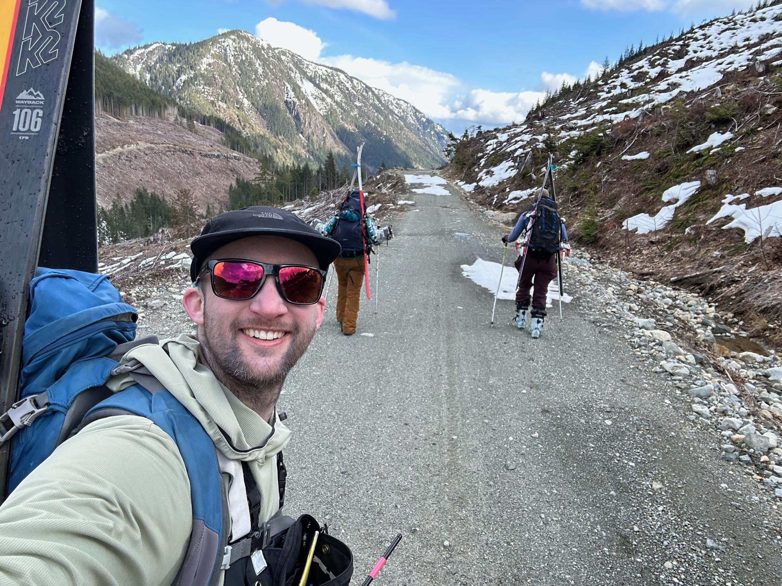
A crack team of researchers hikes, skis, and cores their way to critical water supply data in the mountains of Vancouver Island, British Columbia.
When Hakai Institute science technician Emily Haughton heads up to Castlecrag Mountain on central Vancouver Island, she and her two colleagues take more gear than the usual backcountry campers. For the snowpack measurement field season that begins in the last weeks of winter, among their most essential items are touring skis—and a helicopter.
While the easiest way to access the Castlecrag Mountain base camp on Vancouver Island, British Columbia, is by helicopter, it can be reached later in the season by an eight-kilometer hike. Here, Hakai Institute science technicians Rob White, left, and Emily Haughton, right, hike in with Chloe Swabey of Vancouver Island University’s Coastal Hydrology Research Lab (CHRL). Photo by Rob White
“Getting in any other way with the amount of gear we have would be next to impossible,” says Haughton, noting that their base camp kit includes -20 °C sleeping bags, several meters of metal coring pipe, and a safari-type wall tent with a miniature wood stove. The wall tent functions as their cooking and living area; they have separate tents for sleeping.
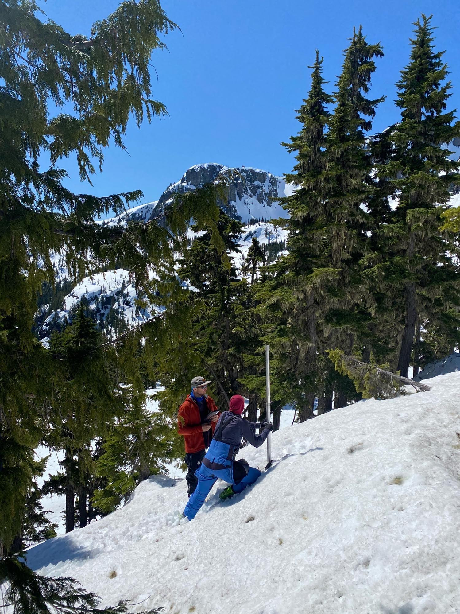
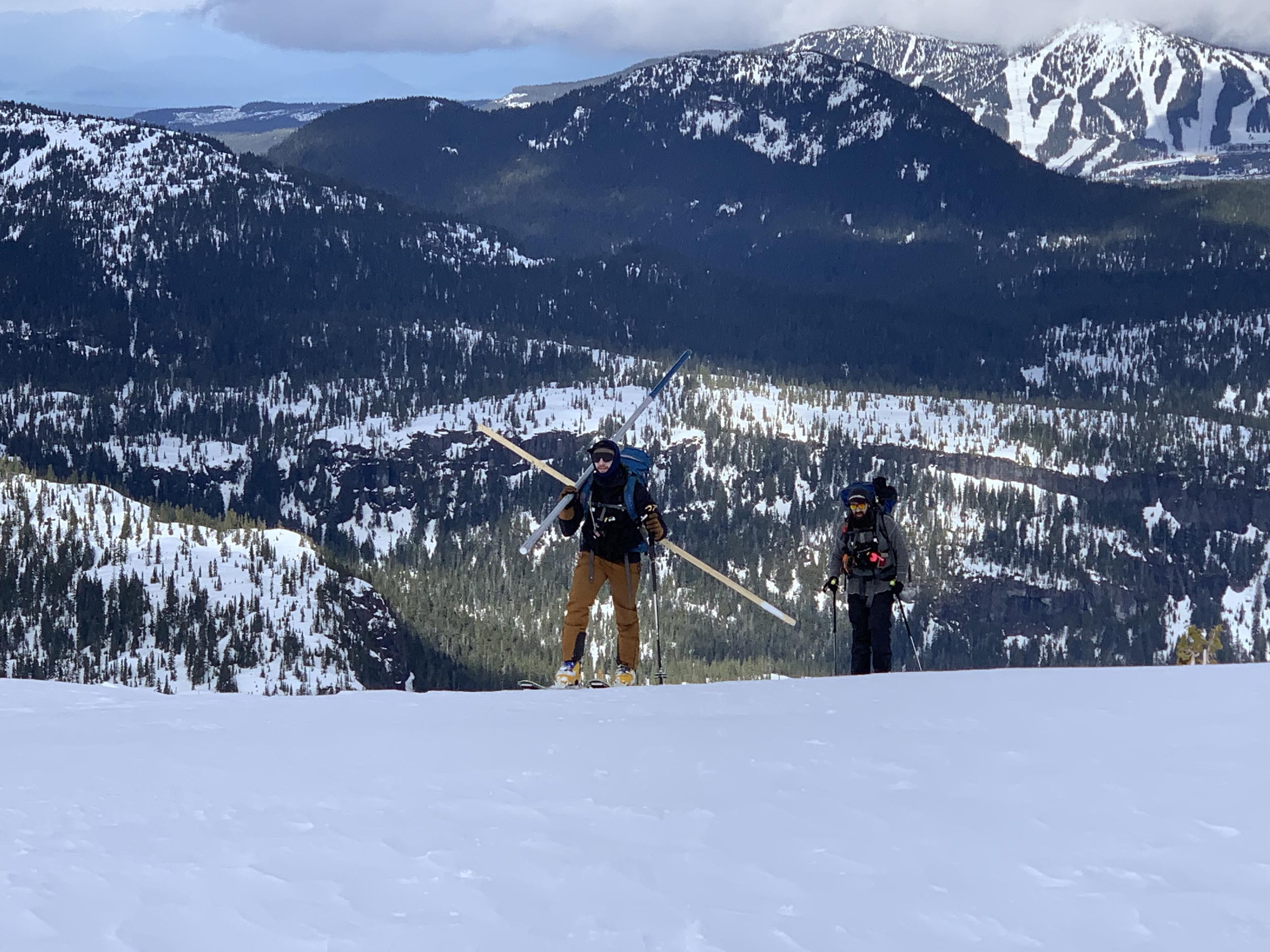
Haughton is accompanied by Hakai Institute science technician Rob White and a rotating member from Vancouver Island University’s (VIU) Coastal Hydrology Research Lab. The chopper flight to the ridge study site at 1,348 meters is about as much of a free ride as they get. After setting up camp, the real work begins the next day: they strap on touring skis fitted with climbing skins to schlep 15-kilogram packs to designated snow coring locations anywhere from one to five kilometers away from camp—much of it uphill.
Once at a designated coring location—there are 10 near their Castlecrag base camp—they assemble the pipe and take five snow cores in a diamond configuration, as well as over 30 depth measurements. The steel or aluminum coring pipe is about four centimeters in diameter and can be extended to six meters. The pipe has serrated teeth at the tip, and by twisting a lateral handle called a driver they are able to drill through up to five meters of snow. In difficult conditions, drilling a single core can take 20 minutes.
Haughton and White take a snow core sample near Castlecrag Mountain. Photo by Alex Cebulski
If this sounds like a workout for—pardon the pun—your core muscles, it is. It’s also a recipe for a sore back. Haughton and her colleagues may or may not have the coolest research gig around, but it is definitely one of the most exhausting. They take up to five trips a year between early March and July, with each trip lasting four to six days.
The purpose of all this toil is primarily practical rather than academic. Their sampling area is within the Cruickshank River watershed in the Comox Valley Regional District (CVRD) of Vancouver Island, and measuring snowpack is key to forecasting the local water supply.
White weighs a snow core on a ridge near Castlecrag Mountain. Photo by Alex Cebulski
It’s part of a greater collaborative effort—bringing together the British Columbia provincial government, VIU, the University of Northern British Columbia, the Hakai Institute, Metro Vancouver, the CVRD, and the Regional District of Nanaimo—to better understand how much snow contributes to freshwater resources for both ecosystem health and drinking water supply.
Their ski-and-backpack alpine sampling regime is done in conjunction with LiDAR surveys carried out by the Hakai Institute’s Airborne Coastal Observatory plane. LiDAR helps map the height of the snowpack; Haughton and her colleagues determine how dense it is. From this they are able to determine the snow-water equivalent, or SWE, a measure of the amount of water contained in snowpack.
“SWE is the money of the snow measurement world,” says Haughton, who did her fieldwork measuring snow cores in the Mackenzie River basin in the Northwest Territories. “It directly relates to how much water could be available during the summer drought season.”
Field observations are fed into a machine learning model that uses LiDAR data and observations from local weather stations to estimate density at a granular scale across the entire watershed, explains Bill Floyd, a research hydrologist with the BC Ministry of Forests. Floyd, a Hakai Institute affiliate, is also director of the Coastal Hydrology Research Lab (CHRL) at VIU.
“By multiplying the depth by density we obtain a SWE estimate every four square meters over an entire watershed,” says Floyd. “This allows us to estimate the total snow water volume in a watershed, something we have never been able to do with such high accuracy.”
The work selects for those who enjoy (and can handle) backcountry skiing—nine-tenths uphill hiking and one-tenth downhill sliding. And whether you’re trudging up or skiing down, says Haughton, “you have to be comfortable carrying large, heavy packs with random tubes sticking out everywhere and negotiating the terrain.”
Laden with coring gear, White and Warren Olmstead of the CHRL trudge to a sampling plot. Photo by Emily Haughton
You also have to be fine with 12- to 16-hour days of alpine camping, with the implied fire-making and cooking to begin and end your days, and with waking up to make your coffee in -15 °C weather. It also means, at times, navigating the overlapping hazards of blizzards, high winds, and avalanches. While snow conditions can be treacherous, Haughton says she will take snow over rain any day.
“The rain saturates the snow, turning it into a wet and mushy mess. This makes touring incredibly hard—you sink past your knees with every step, your skins lose traction, and everything becomes soaked.”
Haughton and her colleagues have counterparts from the CHRL and Metro Vancouver across three other British Columbia watersheds (Tsitika, Englishman, and Seymour Rivers) who feed data into the snow observation program. Depending on the year, in some watersheds up to 40 percent of the water that people use—for drinking, showering, watering gardens, washing cars, and everything else—comes from snow.As of May 11, 2024, the CVRD team had estimated 55.38 million cubic meters of water stored as snow in the Cruickshank River watershed, enough to fill over 22,000 Olympic swimming pools.
“To me, what is really exciting and meaningful about this project is that we are producing a research product that is directly related to how much water will be available for community use,” says Haughton.
“For many of us it can be hard to connect the amount of snow in the mountains with our day-to-day lives. But taking measurements like these has direct implications for water resource management, especially during drought seasons when water preservation is critical.”
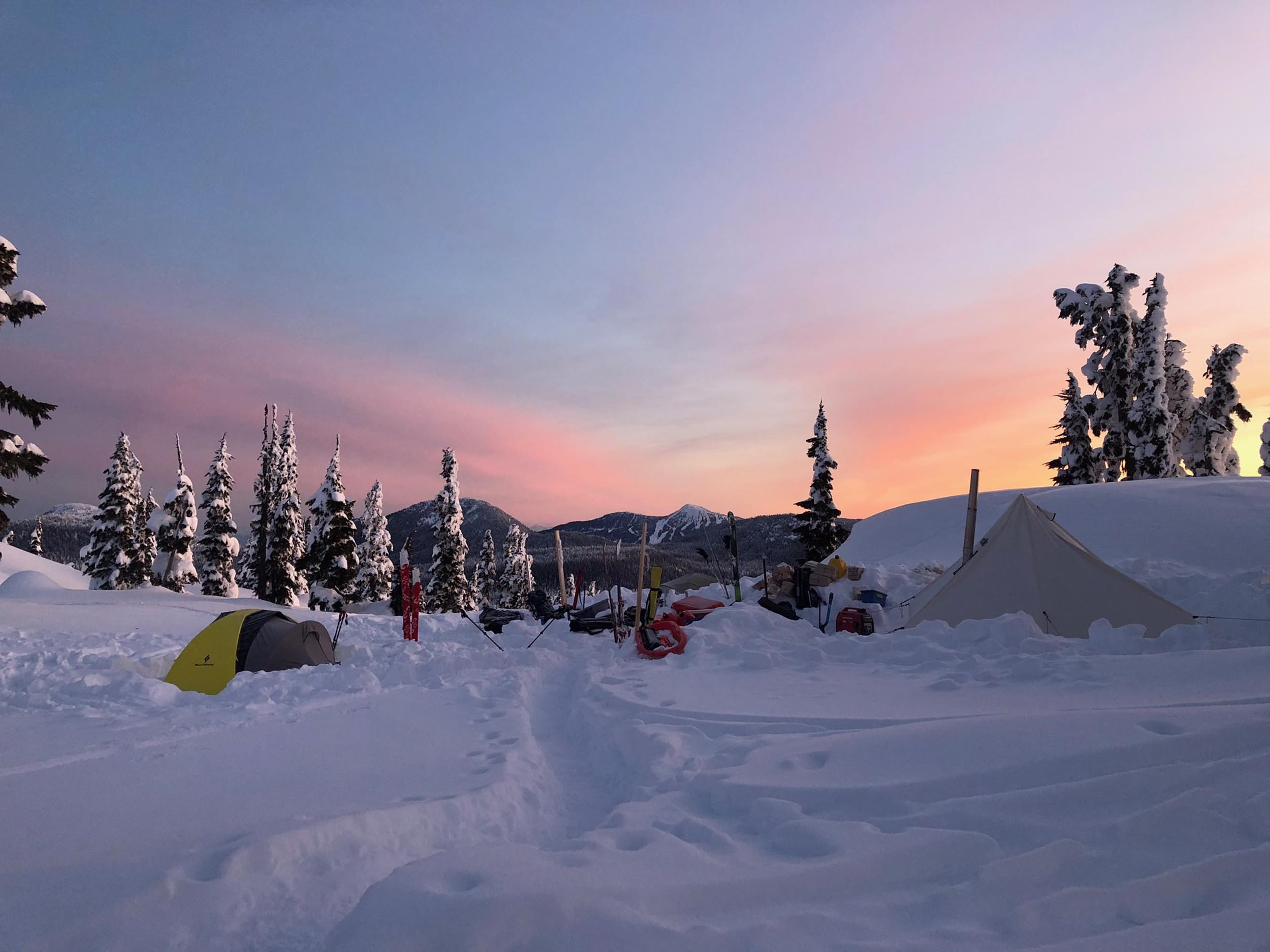
Snowpack research has its rewards, like this lingering sunset over camp. Photo by Alex Cebulski
July 15, 2024
Hakai Magazine Highlights
Check out a selection of some of the most popular and fascinating magazine stories from recent months.
This widely circulated news feature from April focuses on the Gaayhllxid/Gíihlagalgang “Rising Tide” Haida Title Lands Agreement, in which the BC government formally recognizes the Haida Nation’s ownership of all the lands of Haida Gwaii.
The US Department of Energy has awarded US $5-million to three ventures investigating whether seaweed can serve as a practical source of critical materials, such as platinum and rhodium, as well as rare earth elements like neodymium and yttrium.
Active in daylight during the Arctic summer and hibernating during the long winter nights, Alaska’s little brown bats are a unique population. Can their niche lives help them avoid white-nose syndrome?
This photo essay captures some of the astonishing beauty of the smaller echelons of the food web. Researchers at the Hakai Institute’s Quadra Island Ecological Observatory, in British Columbia, spent over three years sampling and photographing zooplankton in the waters off Quadra Island’s eastern shore, a biologically bountiful region where the nutrient-rich outflow of glacial fjords meets the northern extent of the Salish Sea.
This powerful photo essay about sea level rise on a small island in Sierra Leone garnered the most web traffic for the magazine in March and was republished by The Atlantic.
As Great Salt Lake in Utah shrinks, locals are working to preserve its critical brine shrimp fishery—along with the other entities that flourish in the lake’s strange, saline beauty.
Millions of killer culverts lurk beneath North American roadways, strangling populations of migratory fish. Now with a nationwide project, the United States is trying to fix them. This perhaps unlikely story was the most republished article in March and earned a spotlight on Oregon Public Radio.
July 23, 2024
Short Takes
Global Affairs Canada Grants $6-Million to Guatemala SRHR Program
Global Affairs Canada is contributing CAN $6-million to support TulaHealth’s Empowering Indigenous Adolescents and Women for Equitable Sexual and Reproductive Health and Rights (SRHR) project. See the feature article “Something So Crucial” in this issue of the Tula Quarterly.
OceanConnect Now Gives Boaters Data from Alaska to Northern California
OceanConnect is a free service that gives ocean enthusiasts data on wind, waves, currents, and other ocean conditions. A collaboration between the Tula Foundation, the Canadian government, and several universities, it was originally launched in November 2023 with coverage of the Salish Sea in British Columbia and Washington.
In its latest release (Version 1.1), OceanConnect has expanded its forecast coverage tenfold—offering users a heads up on conditions from Southeast Alaska to Northern California—and doubled its live data coverage. These expansions are thanks to the addition of new regional forecast models, and the inclusion of data from hundreds of new live data sources, including buoys, weather stations, tide stations, and webcams.
Reconciliation Through Science
The Nanwakolas Council and the Tlowitsis, We Wai Kai, Wei Wai Kum, Mamalilikulla and K’ómoks First Nations have begun work with the Hakai Institute and other expert advisers on the Nanwakolas 50 Watersheds Project. This science partnership will develop tools to address the threats posed by climate change and forest management on salmon populations and their habitat in the territories of these Nanwakolas member First Nations.
Awards, Awards, Awards
In early June, Hakai Magazine came away from the National Magazine Awards (NMAs) and sister Digital Publishing Awards (DPAs) with four wins—three gold and one silver! Serena Renner’s feature “A River Runs Above Us” took home gold in two categories: Best Topical Reporting: Climate Change at the DPAs and Long-Form Feature Writing at the NMAs. The magazine’s other gold win was for “Banking on the Seaweed Rush” by Nicola Jones, which was named Best Feature Article at the DPAs. Former Tula Foundation journalism fellow Spoorthy Raman won silver in the DPA’s Best Science and Technology Storytelling category for “Shining the Light on Baby Crabs” about the Hakai Institute’s Sentinels of Change light trap project, while Devon Bidal, J. B. MacKinnon, and Moira Donovan all earned honorable mentions.