Back to top
Tula Quarterly Q3, 2024
Join our community Sign up for our newsletter, the Tula Quarterly.

December 6, 2024

Welcome to the Tula Quarterly

Welcome to the third issue of the Tula Quarterly! (Yes, it’s a quarterly that only comes out three times a year—we like to be a little eclectic.) Some highlights from this issue:  

  • Videographer Toby Hall talks about seeing egg-laying skates and a rare giant phantom jelly on the NorthEast Pacific Deep-Sea Exploration Project expedition 

  • Ethnobiologist Chelsey Geralda Armstrong’s new paper—with findings assisted by Hakai Institute genomics researchers—confirms that Indigenous people were cultivating the landscape in British Columbia for thousands of years

  • Researchers are starting to identify DNA from marine sediment cores extracted from Barkley Canyon, 2,000 meters below the ocean’s surface  

This issue’s cover is once again by illustrator Mercedes Minck—inspired by the Hakai geospatial team and the Airborne Coastal Observatory, which appear in two stories in this issue: “Connecting the Dots” and “When a Landslide Unleashes a Flood of Geospatial Data.”

November 18, 2024 | By Kelly Fretwell | Originally published at Hakai Institute

Primed to Detect the Green Crab Invasion

A next-generation DNA sampling tool is alerting coastal communities to the spread of an infamously destructive invasive species.

Primed to Detect the Green Crab Invasion

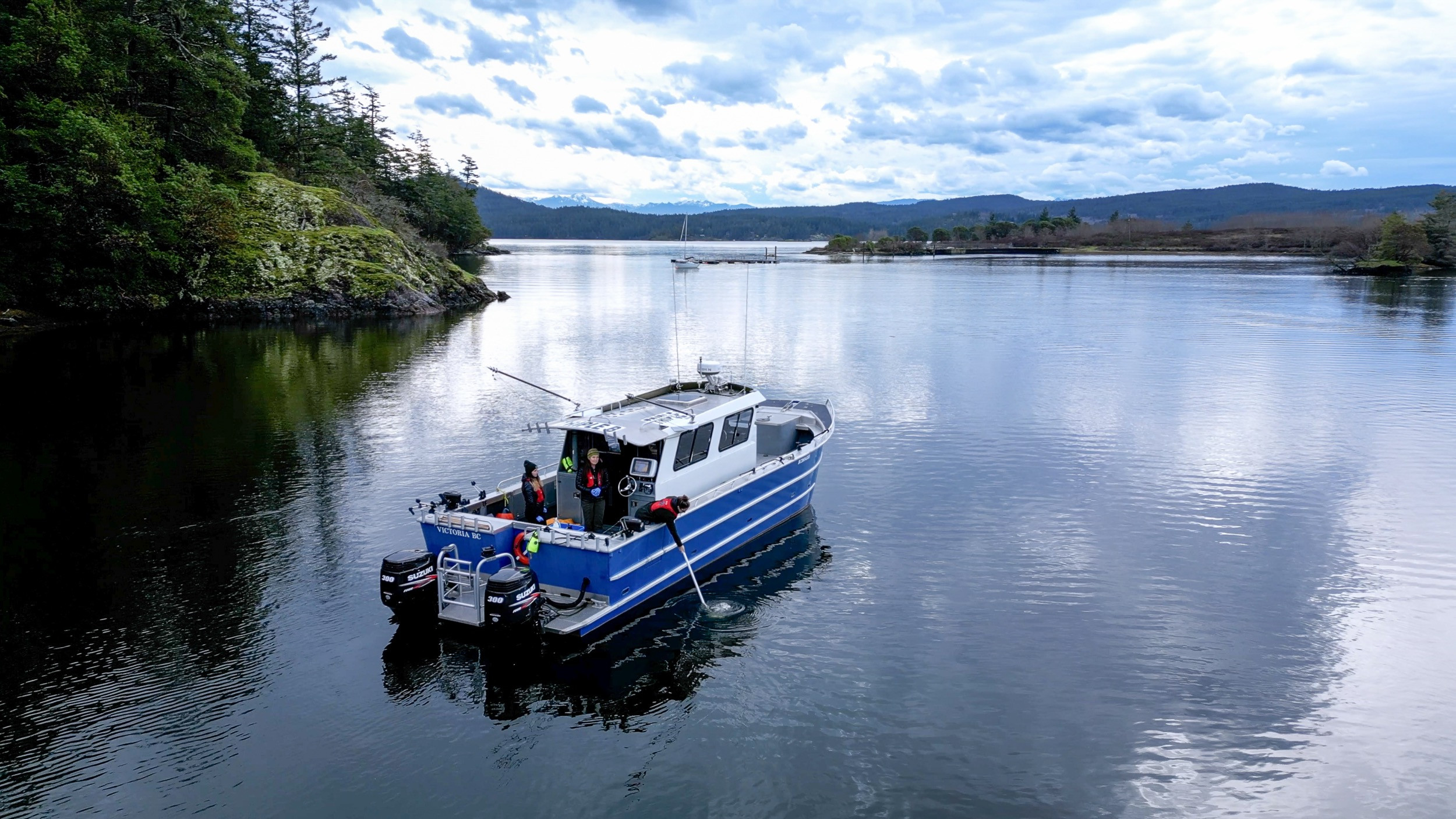
An ICO eDNA sampling takes place on board the vessel the Ryan Sea in the Sooke Basin, British Columbia.

On the British Columbia coast, an insidious invasion is happening below the waves, one poised to substantially alter nearshore ecosystems if left unchecked. 

The invader? A shore-dwelling crustacean called the European green crab.

At first glance, these interlopers look innocuous: with shells measuring 10 centimeters across, they’re not much bigger than BC’s native shore crabs. But they have a well-earned reputation as one of the most destructive marine invasive species in the world, with a plethora of direct and cascading impacts, both ecological and economic. 

Hardy, adaptable, and prolific, European green crabs are thought to have first arrived in North America in the 1800s in the ballast water of ships, and they have since been found at specific locations from Mexico to Alaska. These efficient predators feed on a wide range of native species, from juvenile fish to other crustaceans, and they out-compete native crabs for food. They also can destroy eelgrass meadows and shellfish beds while feeding or burrowing for shelter.

Primed to Detect the Green Crab Invasion

European green crabs are relatively small, but where their population numbers boom, the invasive species’ impacts can be substantial. Photo courtesy the Coastal Restoration Society

For most people, this invasion is out of sight and out of mind, but for those whose lives intertwine with coastal ecosystems it’s a growing concern, especially as the crabs continue to colonize new areas. To give coastal communities and ecosystems a better chance of responding to and managing the threat of invasive green crabs, a new tool is being deployed by scientists at the Hakai Institute—one that will make it easier for a network of community partners along the coast to detect and get ahead of these invaders, even before laying eyes on them.

This early warning tool hinges on environmental DNA: the bits of genetic material that green crabs, like every organism, leave behind in their environment. 

“We work a lot with citizen science groups using eDNA to measure biodiversity,” says Hakai Institute scientist Matt Lemay, the science lead for the Integrated Coastal Observatory (ICO). ICO is a Hakai-led network of partner organizations that includes Parks Canada, First Nations and citizen science groups.

ICO partners collect monthly seawater samples along the BC coast and send them to the Hakai Institute’s Quadra Island Ecological Observatory for sequencing and analysis.

“The focus of ICO’s work has been on marine fish diversity since the initiative began in 2019,” says Lemay, “but from the outset partners were looking for ways to monitor this invasion.”

Primed to Detect the Green Crab Invasion

ICO network coordinator Sue Velazquez collects a seawater sample while training Coastal Restoration Society staff on eDNA collection in the Sooke Basin, British Columbia.

Now Lemay, ICO network coordinator Sue Velazquez, and the rest of Hakai’s ICO project team are nearly ready to deliver on that request.

Coastal waters teem with eDNA. Even the smallest organisms shed genetic traces of their presence through things like skin cells, scales, or mucus. The trick, however, is being able to accurately detect DNA of a single species—in this case, green crab—amongst the ocean’s swirling soup of genetic material. 

That’s where part one of this important initiative comes into play. Hakai’s ICO team has been working to optimize a targeted genetic tool to isolate and detect any traces of eDNA from green crabs—and only green crabs—in a sample. 

Known as qPCR (quantitative polymerase chain reaction), what distinguishes it from traditional approaches is the “quantitative” aspect:  these tests can go beyond revealing the simple presence/absence of a species to shed light on its relative abundance in an area. 

A key part of the tool, called the primer, binds to and amplifies the target DNA, and a new piece of tech called a digital droplet PCR instrument helps the ICO team detect it amidst the melange of background DNA. 

The team has been busy putting the new green crab tool through its paces, using the archive of seawater samples collected by ICO partners over the past few years—specifically those samples from areas where the species is known to exist, notably on western and southern Vancouver Island. Parks Canada and the T’sou-ke Nation, respectively, are actively monitoring European green crab in each of those locations. 

“It’s exceeding my expectations,” says Lemay. “If there’s any shred of green crab DNA in the water this tool should detect it. At this point I suspect that we can get to really low, hopefully first wave, detections.”

Primed to Detect the Green Crab Invasion

Some organizations actively trap European green crabs as a control measure in locations where the invasive species has established populations. Photo courtesy the Coastal Restoration Society

“Many ICO members have heard of a green crab being spotted or captured in areas where they weren’t before, and they’re quite concerned about it,” says Velazquez. “Early detection is the most valuable thing for a lot of groups because most aren’t out there observing it in the field.”

Green crab DNA shows up in ICO seawater samples year-round, says Lemay. This indicates that qPCR testing picks up on green crab DNA from all life stages—meaning the Hakai ICO team won’t need to time their sample analysis to the crab’s life cycle. 

“You don’t know what that genetic material is–if it’s coming from adults, if it’s coming from larvae, if it’s coming from spawning,” says Lemay. “I was surprised to see how abundant the DNA was year-round. Clearly the adults are shedding a lot and there’s a strong signal at any time. Which is great for detecting. There’s less chance that you’d miss it.”

Before the team rolls out the green crab tool for network-wide use, they need to finalize part two of the initiative: data accessibility. It may sound less exciting, but making the results publicly accessible, and quickly, is just as vital as the eDNA sampling and sequencing. 

While other groups are also implementing eDNA testing to monitor for European green crabs, to Lemay’s knowledge this coordinated, coast-wide, and open-access approach to tracking the invasion is unique. 

“It’s going to be amazing. It’s essentially a real-time data visualization of detections in BC at these partner locations. I don’t think there’s any existing tool or network that’s doing that.”

These detections could, in turn, warn others to be on the lookout—and potentially entice more groups to join the ICO network.  

To learn more about the green crab invasion in the northeast Pacific, check out this Hakai Institute “Nature Files” video, The Case of the Colonizing Crabs, and the Hakai Institute Long Story Shorts video How Do Invasive Species Take Over?

November 7, 2024

Connecting the Dots: Democratizing Geospatial Data

Canada is a world leader in gathering geospatial data, but what do you do when you have more high-quality data than you can use?

Connecting the Dots: Democratizing Geospatial Data

The Hakai Institute’s Airborne Coastal Observatory (ACO), a Piper PA-31 equipped with a suite of Earth-imaging instrumentation, has enabled the Hakai Institute to gather vital geospatial data. Among other applications, ACO data has assisted efforts to assess the aftermath of floods and landslides, and assess the potential of future geohazards.

The invention of light detection and ranging (LiDAR) revolutionized the field of land surveying. LiDAR uses laser altimetry to create precise, three-dimensional maps and models of terrain and ecosystems.

Canada is a recognized leader in the collection and analysis of Earth observation datasets, and the Hakai Institute geospatial team has been at the forefront of mapping British Columbia’s dynamic coastal landscape, from ice fields to the ocean. This is in large part thanks to the Airborne Coastal Observatory, an airplane equipped with LiDAR and other complementary instruments.

Canadian expertise in gathering geospatial data may come as no surprise, given the vastness of the country’s landmass, but it comes with a puzzling challenge: what to do with it. 

Connecting the Dots: Democratizing Geospatial Data

Geospatial specialist and ACO operator Steve Beffort monitors incoming ACO LiDAR and imagery data.

“Geospatial information underpins everything we do and helps us better understand our environment,” says Derek Heathfield, the Hakai Institute’s geospatial technologies program lead. 

“But a problem definitely exists, in that geospatial data is often quite bulky—meaning that it produces huge files and data in forms that are hard to transfer and hard to share. For anyone who is not a specialist, geospatial data is generally difficult to work with. It’s hard to view and to analyze, and it’s hard to actually extract actionable information from it.”

There are many people and groups that would benefit from easier access to geospatial data, says Heathfield. These include First Nations land and fisheries managers, municipalities, park rangers and administrators, and analysts and decision-makers in provincial and federal agencies.

“The need for data becomes really clear in a rapid response situation,” says Heathfield. “In a situation like the Chilcotin landslide, everyone is saying, Wow, we just had this landslide happen, what data do we have of the area from before the slide to assess the changes?”

Any kind of geohazard event, whether landslide, flood, or wildfire, can bring a  need for pre-existing geospatial data. 

Connecting the Dots: Democratizing Geospatial Data

When a slump landslide blocked the Chilcotin River on July 28, 2024, the river backed up for nearly six days before gradually breaking through—a welcome outcome instead of a catastrophic flash flood. Photo by Brian Menounos

“In those situations, you don’t want to have to wait too long for your specialist to dig up the information you need from the archives,” notes Heathfield. “What you need is timely, actionable spatial information to help make appropriate emergency management decisions.”

In order to improve access to data, Natural Resources Canada (NRCan) established the GeoConnections funding program with a mandate to lead the evolution of geospatial data infrastructure in Canada.  

In 2024 the Hakai Institute received GeoConnections funding to develop and test a scalable, cloud-optimized Application Programming Interface (API) that is web-based and easily accessible by multiple user groups. The project will use LiDAR data from three case-study regions in British Columbia that have experienced recent landscape-altering events: Elliot Creek, Mount Robson Provincial Park, and Place Glacier.

Connecting the Dots: Democratizing Geospatial Data

The Airborne Coastal Observatory collected this LiDAR-derived point-cloud image of Mt. Robson Provincial Park in 2023.

“We selected regions where climate change impacts Indigenous communities, freshwater availability, and tourism,” says Heathfield. “What we ultimately want is for a user to be able to just put a URL into their browser, and up comes a portal where they can navigate to the data they want.”

Heathfield likens it to streaming music on a platform like Spotify.

“You haven't had to download a massive file, or purchase expensive and complicated software. It seems like a simple thing, but it really does democratize and open up what we call FAIR use of data—findable, accessible, interoperable, and reusable.”  

Heathfield cites the example of NASA’s approach to open science and open data as a formative influence. 

“That was kind of the inspiration, where we looked at their work and said, hey, we could be doing this too with all the LiDAR from the ACO. It's within our strategic mission to have that data put to public use, and we can only do so much ourselves with it, but if we have it open and available, it gets used more. That's just good for everybody."

December 6, 2024 | Originally published at Hakai Magazine

Mouthfuls of Microplastics

Hakai Magazine’s “In Graphic Detail” articles use a compelling visual to illustrate a fascinating fact or troubling reality, from the architecture of octopus burrows to the ballooning size of cruise ships.

Mouthfuls of Microplastics

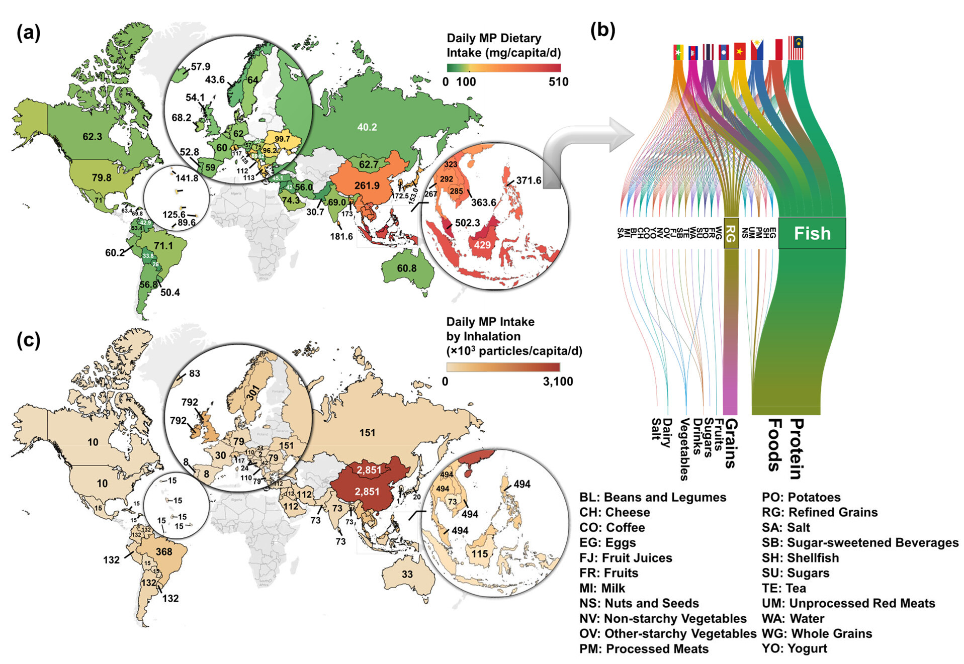
We’ve all heard about microplastics being found in rainwater, but it seems they also exist much closer to home: in our diets. A new Cornell University study of 109 countries shows that, as plastic production has increased 240-fold in the past few decades, the amount we consume through food, water, and even air has increased significantly—and is also affected by where you live.

People who live in Asia, Africa, and the Americas are eating and breathing six times more microplastic on average than in 1990. The highest rates of dietary microplastic consumption are in Southeast Asia, where about 70 percent of microplastic comes from seafood.

Topping the list is Indonesia, where an estimated 15 grams (three teaspoons worth) of microplastic is eaten per person every month.

In China and Mongolia, people inhale around 2.8 million airborne particles of microplastic, largely from industrial manufacturing and urban activity, every day.

The study’s authors argue the only way to combat the consumption of microplastics is to eradicate plastic pollution, which is the ambitious goal of a recent global microplastics treaty.

December 4, 2024

Fighting Ocean Pollution, One Research Kit at a Time

A new collaboration brings low-cost pollution monitoring to coastlines around the world.

Fighting Ocean Pollution, One Research Kit at a Time

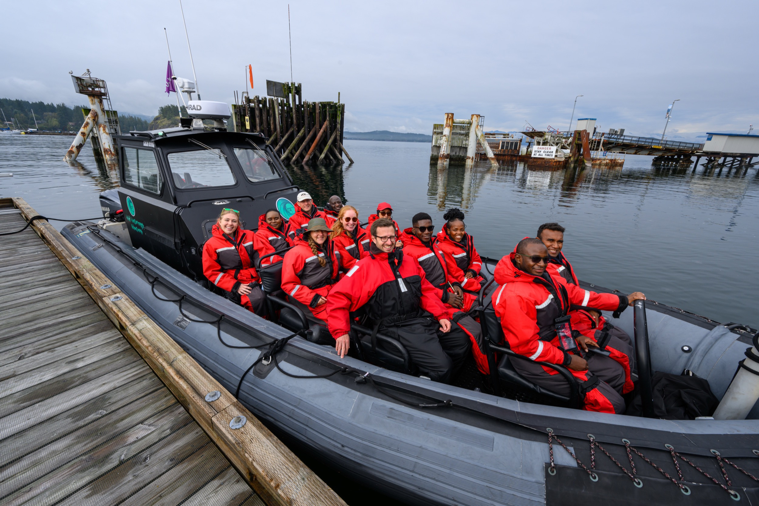
GEM participants, instructors and support staff (from the Hakai Institute, Fisheries and Oceans Canada, and The Ocean Foundation) suit up for a tour of Quadra and surrounding islands with Wild Waterways Adventures.

Ocean ecosystems are facing a gauntlet of threats, from rising temperatures to microplastics, but one of the leading causes of ocean pollution is largely out of sight: nutrients. Over the past 50 years, the growth of farming, aquaculture, and coastal populations has meant more nutrients like nitrogen and phosphorus flowing into the ocean. 

Upward of 900 marine areas around the globe suffer from excessive nutrient enrichment, or eutrophication, which can lead to harmful algal blooms and low-oxygen dead zones that can wipe out marine ecosystems. Yet the full scale of the problem is unknown due to lack of data.

A two-year pilot project called GEM-in-a-Box aims to fill in the gaps through low-cost nutrient monitoring around the world, from Kenya to Malaysia to the Bahamas. GEM stands for Global Eutrophication Monitoring, and the initiative is led by the Commonwealth Blue Charter Action Group on Ocean Observation, in partnership with the Tula Foundation, Fisheries and Oceans Canada (DFO), and The Ocean Foundation.

In late September 2024, scientists from Southeast Asia, Africa, the Caribbean, and the Solomon Islands gathered at the Tula Foundation’s Quadra Island Ecological Observatory for a training workshop to test out the GEM-in-a-Box kit. Over five days, participants learned to measure ocean nutrients as well as other oceanographic indicators—dissolved oxygen, salinity, chlorophyll, conductivity, temperature, and depth—with easy-to-use instruments that come in one portable kit. 

Fighting Ocean Pollution, One Research Kit at a Time

GEM participants Nokubonga Mbandzi-Phorego, center, and Brandon Bethel, right, learn how to use instrumentation in the GEM-in-a-Box kit, under the guidance of Hakai Institute instructor Justin Del Bel Belluz.

While each GEM-in-a-Box kit costs around CAD $30,000, workshop participants will receive them for free at their home institutions, thanks to funding from DFO and the Paul G. Allen Family Foundation, lowering the barriers to monitoring and enabling high-quality data generation. This in turn will enhance regional understanding and decision-making.

Despite the chilly temperatures that greeted them on Quadra Island, participants—most hailing from tropical climates—enthusiastically got their hands and feet wet in the northeast Pacific to learn all they could about using the GEM-in-a-Box kits. The cold weather wasn’t the only new experience for many attendees; they were also treated to sightings of humpback and killer whales, Steller sea lions, and bald eagles.

“I was so inspired by their willingness to immerse themselves in the workshop, learn together, and share their experiences and challenges with their own work back in their home countries,” says Tula Foundation project manager Naomi Boon, who helped organize the training workshop. 

“It was really rewarding to hear from the participants just how much they need the equipment that is contained within the GEM-in-a-Box kits.” 

Eric Okuku is a case in point. A researcher with the Kenya Marine and Fisheries Research Institute, Okuku traveled all the way from Mombasa, Kenya, where the population has grown 16-fold since 1950—from around 93,870 people to nearly 1.5 million—far outpacing sewage infrastructure. 

Fighting Ocean Pollution, One Research Kit at a Time

Workshop participants Nokubonga Mbandzi-Phorego, left, and Brandon Bethel practice sampling methods on the Heriot Bay dock on Quadra Island.

“Only one sewage system is working, and the efficiency is between 20 to 30 percent,” Okuku says. “That means that most of our wastewater is discharged into the ocean raw—so, not treated.” 

Waterways like Kenya’s Sabaki River also pick up soils and fertilizers on their journey from the agricultural interior to the coast, pumping tonnes of sediment and nutrients into the ocean, Okuku adds. The combination of sewage and nutrients is harming coral reefs, contaminating marine foods—from shrimp to snapper—and affecting coastal livelihoods. Combined with other threats, the picture isn’t pretty.

“We are talking about areas that are overfished and where climate change is already there,” Okuku says, “and then we add another stressor from pollution and this is how these ecosystems collapse.”  

Enter GEM-in-a-Box. Okuku plans to conduct monthly tests of three different nutrients (nitrogen, phosphorus, and silicate), in addition to other oceanographic conditions, at 15 sites along the Kenyan coast.

Fighting Ocean Pollution, One Research Kit at a Time

Hakai Institute instructor Drew Jordison, left, demonstrates sampling equipment for GEM participants in the field.

“Africa is a data-poor continent,” Okuku says, “and without data, the levels of how serious things are can never be known. And if they’re unknown, nobody will act.”

Sazlina Salleh has similar goals in her home country, Malaysia. A researcher and lecturer at the Centre for Policy Research at University of Science Malaysia, Salleh is concerned about the growing aquaculture industry off the coast of Penang, which—combined with changes in climate patterns—may have contributed to nearby algal blooms and fish kills. These events frequently occur during seasonal changes and have impacted the aquaculture sector in the region, Salleh adds.

“When I heard about the kit, we thought, Oh, we can get fast results to the aquaculture farms to help them come up with a solution,” Salleh says. “And we can convey this data to the authority that, Hey, look, this area needs to be managed properly. You can’t allow the increase of aquaculture without providing proper management and mitigation plans.”

Fighting Ocean Pollution, One Research Kit at a Time

Hakai Institute instructor Zoe Sandwith, left, reviews GEM-in-a-box equipment procedures with participants, from left, Ernest Ohandja Nomo, Aleisha Dennie, and Lindon Havimana at the Meeting House on Quadra Island.

Beyond local and national monitoring, the GEM-in-a-Box program aims to create a standardized global database to broaden our understanding of eutrophication and its impacts around the world. In the process, the project will help advance United Nations’ Sustainable Development Goals, along with the UN Decade of Ocean Science for Sustainable Development.

“Getting the data from the participants’ projects into a centralized repository and making it accessible to others is key,” Boon says. “This will allow us to make comparisons and to evaluate the impact of the kits.”

She adds that she’s hopeful that funding and training will extend beyond the two-year pilot project.

Expanding the project to neighboring countries and shining a light on eutrophication is the only way to tackle the issue, says Okuku. He compares it to plastic pollution, which didn’t receive the attention it deserved until a global campaign rose up to address it.

“Kenya has the best laws dealing with plastic because it is something that we see every day, something you can make noise about,” Okuku says. “Nobody can see sewage, but we are giving sewage a good look. Together, I hope we can fight pollution issues arising from eutrophication.”

December 6, 2024

ICO Partnership Crowdsources Biodiversity Research

The Integrated Coastal Observatory empowers British Columbia communities to track biodiversity in their coastal waters.

ICO Partnership Crowdsources Biodiversity Research

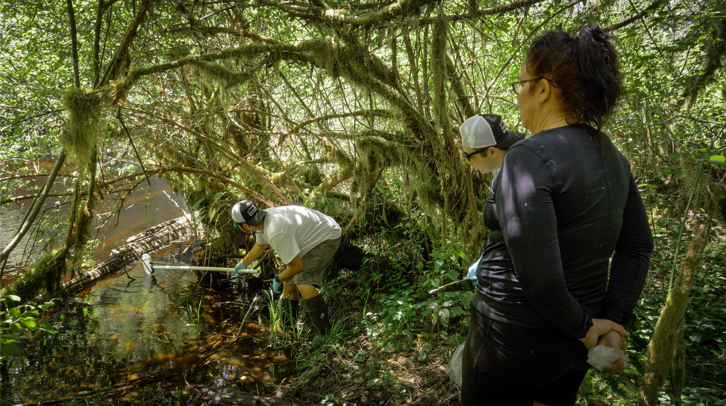
Da’naxda’xw Guardians take part in an eDNA field sampling training on the Campbell River. Photo by Sue Velazquez

British Columbia encompasses 29,000 kilometers of coastline, with much of its biodiversity largely unexplored. Hakai researchers use environmental DNA (eDNA) sampling as an efficient, non-invasive approach to biodiversity monitoring, but they can only cover so much ground—or water—on their own.

Enter Hakai Insititute’s Integrated Coastal Observatory (ICO), which engages a partner network of citizen scientists, First Nations communities, and various research organizations to collect monthly eDNA samples. Once processed at the Hakai Institute’s Quadra Island lab, the samples help to map fish biodiversity in nearshore habitats along BC’s coastal margin. 

ICO Partnership Crowdsources Biodiversity Research

ICO partners receive an eDNA field sampling kit in order to collect monthly samples. Photo by Sue Velazquez

How does it work? ICO project manager Sue Velazquez developed a low-tech eDNA sampling kit that can easily be shipped to partners to collect samples. ICO partners are trained in person or via an eDNA sampling kit training video produced by Hakai. Partners receive their kits monthly, collect samples, and send them back to Quadra Island to be processed. 

Curious about what happens to the samples once they make it back to our lab? ICO partners were too, so the Hakai team made a video to describe what happens behind the scenes of ICO.  

ICO Partnership Crowdsources Biodiversity Research

Gina Thomas, a Tlowitsis Guardian, filters the collected ICO eDNA samples. Photo by Sue Velazquez

“We’re very grateful to our partners for their commitment and huge contribution to this project,” says Velazquez. “Together we’re helping to transform our understanding of fish biodiversity across BC’s nearshore marine environment.”

Hakai researchers share the data from these samples back with our partners so that it can be used for local conservation and stewardship efforts. ICO has processed almost 2,300 samples since it began in 2019, and the samples keep coming in. Learn more about ICO and explore the data yourself at https://ico.hakai.org.

November 26, 2024

When a Landslide Unleashes a Flood of Geospatial Data

A landslide blocked the Chilcotin River in July 2024, threatening to unleash a devastating flood. Hakai Institute affiliate Brian Menounos was on the scene to assist in assessing the extent of the hazard and its potential impacts.

When a Landslide Unleashes a Flood of Geospatial Data

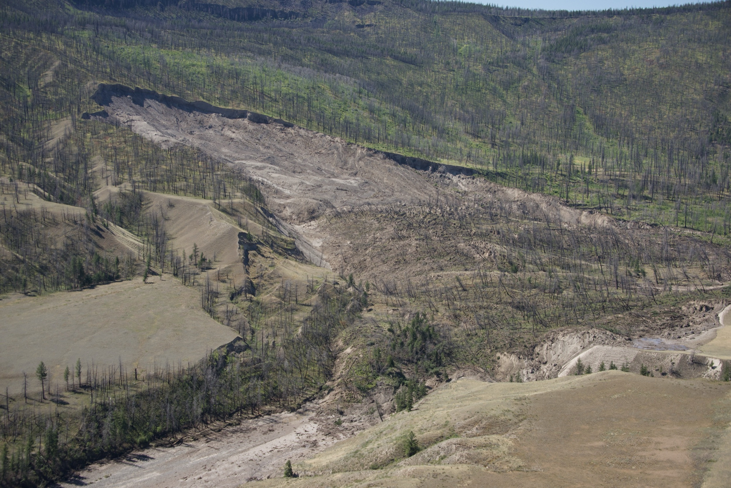
A photo taken from a helicopter shows the landslide—six million cubic meters of surface material, still bearing vegetation and burned trees. The dry riverbed can be seen in the lower left. Photo by Brian Menounos

The slope gave way in the night, like half a million dump trucks unloading all at once. A man camping beside the Chilcotin River heard the rumbling upheaval of boulders, silt, sand, and clay above him and fled his tent just in time.

The material slammed into the river—a tributary of the Fraser River, about 285 kilometers north of Vancouver, British Columbia—and dammed it, causing water to pool upstream in a lake that soon began to fill the valley.

On July 31, the day after the landslide, Brian Menounos, an earth scientist at the University of Northern British Columbia, got a call from the Ministry of Emergency Management and Climate Readiness (EMCR). The agency, which coordinates and supports emergency response across the province, was reaching out to subject matter experts to conduct an initial hazard assessment of the slide.

Menounos, a Hakai Institute affiliate who runs the Airborne Coastal Observatory (ACO) program, is no stranger to hazardous slides. He studied the massive 2020 landslide and tsunami in Bute Inlet, on the BC coast, and helped conduct an inventory of past, present, and future landslides in the Fraser River Canyon, after the Big Bar slide partially blocked the river in 2019.

Hopping into a helicopter, Menounos and Marten Geertsema, who studies landslides and other natural hazards with the province’s Ministry of Forests, flew south from Prince George to check out the scene.

When a Landslide Unleashes a Flood of Geospatial Data

Brian Menounos sets up a GPS system that will be used to measure the lowest elevation of the landslide debris—the spot where the lake would eventually begin to spill over the dam, triggering its collapse. The scar from the landslide is visible on the opposite bank of the Chilcotin River behind him. Photo by Adam Hawkins

They were impressed by what they saw. Trees blackened in a 2017 wildfire still stood upright on top of the enormous mound of sediment that filled the river. Downstream of the blockage, where Big Creek met the Chilcotin River, water was still flowing, but immediately below the dam, the riverbed was nearly dry.

Menounos and Geertsema recognized the urgency of the situation: they knew the earthen dam would fail. The lake behind the slide was growing steadily. Eventually, the water level would rise enough to spill over the top, eroding the dam and releasing water to surge downstream through the Chilcotin and Fraser Rivers. If the dam disintegrated rapidly—a worst-case scenario—the resulting flood could be catastrophic for communities and infrastructure in its path.

“It was really important to acquire data as quickly as possible,” Menounos says.

On top of the danger, the timing of the blockage was particularly bad for salmon. Sockeye and chinook salmon populations were actively migrating upstream in the Chilcotin River when the slide blocked their progress. Some fish, such as the chinook that spawn in the Upper Chilcotin River, had fortunately reached their spawning grounds before the slope collapsed. But others—including Chilko Lake sockeye, one of the largest salmon populations in the watershed—were still downstream.

When a Landslide Unleashes a Flood of Geospatial Data

Hakai Institute affiliate Brian Menounos and British Columbia Ministry of Forests geoscientist Marten Geertsema scouted the landslide from a helicopter. The landslide dam can be seen on the right side of the image, cutting off the Chilcotin River and leaving the riverbed mostly dry—though some water still flowed into the riverbed from Big Creek below the dam. Photo by Brian Menounos

The Tŝilhqot'in Nation leadership declared a local state of emergency. The EMCR issued flood warnings along the Fraser River and issued an evacuation order upstream and downstream of the slide.

Menounos and Geertsema, meanwhile, flew home to Prince George to pack field gear and camping equipment; they then drove back to the site. Working alongside government scientists, consultants, and First Nations representatives, their task was to estimate the size of the dam, the potential volume of the lake behind it, and how fast the lake was filling—all to help forecast when the water would begin spilling over the dam and trigger its failure.

The Hakai Institute’s ACO plane flew over the site multiple times with LiDAR, using lasers to create a 3D model of the area surrounding the slide. Drone operators from Spexi Geospatial, a Vancouver-based aerial imagery company, photographed the slide from all angles to map its contours and determine how it might be changing over time.

When a Landslide Unleashes a Flood of Geospatial Data

The Chilcotin River backed up behind the landslide, as dead trees and other debris accumulated in the newly forming lake. Photo by Brian Menounos

Back at the Hakai Institute office in Victoria, members of the geospatial team dropped everything to help, processing LiDAR data of the Chilcotin River. This was data that Kîsik Aerial Survey had serendipitously collected just months before, as part of a GeoBC effort to map the entire province; it allowed Hakai Geospatial to create a “before” model of the area and compare it to post-slide LiDAR data to see how the terrain had changed.

Drawing from all of these sources, the researchers determined that the dam was roughly 1,000 meters long, 600 meters wide, and 30 meters tall. Menounos estimated that the landslide had displaced enough soil, sand, and rock—six million cubic meters—to blanket the city of Victoria, British Columbia, up to an adult’s shins.

The lake backing up behind the massive pile of debris stretched 11 kilometers long. On the morning of August 5, six days after the slide, Menounos, Geertsema, and their on-site collaborators were watching the lake, now level with the height of the dam, waiting for the moment it would overflow.

“The water fills lower points in the dam first,” Menounos says. “We were guessing where we thought the dam was going to breach.”

When a Landslide Unleashes a Flood of Geospatial Data

Comparing post-slide LiDAR data to information collected the previous May, Hakai Institute’s geospatial team produced a map showing how the terrain’s elevation changed as a result of the event. Map by Hakai Institute Geospatial, using data from GeoBC

As the water began trickling over the edge of the slide in miniature waterfalls, it cut into the sediment, carving channels in the top and front of the dam. These grew bigger and bigger, as more muddy water poured through, cascading into the river channel below. Chunks of the slide debris fell away, earth and rocks disappearing into the coursing water downstream.

But the dam didn’t collapse right away. The reason, Menounos says, is geology: some of the boulders, silt, sand, and clay that made up the slide had been heavily cemented together. This type of sediment, which geologists call a diamicton, almost behaves like rock; dense and compact, it is difficult for water to cut through.

The diamictons peppered throughout the dam slowed down its failure. As a result, the lake took roughly 20 hours to drain, and the downstream surge was smaller—and less destructive—than the worst-case scenario that everyone had feared.

“It would have been a much more rapid collapse if not for those deposits,” Menounos says. “If the dam had incised twice as fast, then the magnitude of the flood would have been much, much larger.”

When a Landslide Unleashes a Flood of Geospatial Data

Roughly six hours after the dam breached, the Chilcotin River had cut a deep channel through the landslide debris. In the background, the landslide scar is visible on the slope as a lighter, sandy area surrounded by greener foliage and blackened tree trunks. Photo by Brian Menounos

Fortunately, no one was injured in the flood, though the high water damaged important Indigenous cultural sites along the Chilcotin and Fraser Rivers—including historical Secwépemc house pits and burial sites—and other properties downstream. The Tŝilhqot'in National Government closed a bridge over the Chilcotin River below the slide, worried it could be unstable.

Hakai Geospatial performed an additional ACO survey after the dam was breached, and again a few weeks later, looking for more landslides. Riverbanks that had been saturated with water along the edge of the lake will become less stable, Menounos explains, meaning those slopes can fail as the water recedes. The floodwaters churning downstream also eroded and undercut slopes, pulling more sediment into the river.

In mid-September, six weeks after Menounos and Geertsema returned home, two separate, smaller slides did occur downstream of the original site. Both also barred the upstream migration of adult salmon, though the river cut through each blockage within 24 hours.

By October, Fisheries and Oceans Canada had counted nearly 6,500 chinook and roughly 65,000 sockeye migrating past the landslide area—though the numbers were lower than expected for 2024, the slide’s impact had been less severe than the Big Bar emergency in 2019. Hakai Geospatial adapted a mapping tool originally developed for the Fraser River Canyon landslide inventory to depict which salmon populations were affected by the Chilcotin River slide, using data from Fisheries and Oceans Canada, the Pacific Salmon Foundation, and Simon Fraser University.

When a Landslide Unleashes a Flood of Geospatial Data

A map shows the salmon species and spawning habitat in the Chilcotin, Fraser, and Taseko Rivers that were blocked by the July 30 landslide in the Chilcotin River, upstream of Farwell Canyon, known as Nagwentled in the Tŝilhqot'in language. Map by Hakai Institute Geospatial

This region of the Fraser River watershed has seen events like these for millennia, Menounos explains. Several thousand years ago, a large landslide also ran right across the Fraser River downstream of Lillooet. And the landslide on the Chilcotin River occurred just upstream of Farwell Canyon, where a similar landslide also dammed the river in August of 1964. The Tŝilhqot'in name for the canyon is Nagwentled, which roughly translates to “landslides across the river.”

But never before have geologists had the luxury of having so much information from both before and after a landslide. “This was probably one of the best-documented damming and then subsequent breaching events along a river that we’ve ever had—not just in BC, but in probably many places in the world,” says Menounos.

“We’re kind of in an era of unprecedented availability of digital data and geospatial data.” 

December 6, 2024

Going Remote—and Deep

Members of the NEPDEP 2024 expedition saw many wonders as they explored the seamounts and deep-sea ecosystems off Haida Gwaii in northern British Columbia; the Hakai Institute’s Toby Hall returns to tell the tale

Going Remote—and Deep

The ROPOS submersible, aboard the Canadian Coast Guard vessel John P. Tully, is lowered via a mechanical arm into calm Pacific waters. Photo by Fisheries and Oceans Canada/Toby Hall

In September 2024, the NorthEast Pacific Deep-Sea Exploration Project (NEPDEP, pronounced “neep-deep”) completed a three-week expedition of the deep-sea ecosystems off the coasts of Haida Gwaii and Vancouver Island. The project is a collaboration between the Council of the Haida Nation, the Nuu-Chah-Nulth Tribal Council, Fisheries and Oceans Canada, Royal BC Museum, University of Victoria, and Ocean Networks Canada.

Based on board the Canadian Coast Guard vessel John P. Tully, the expedition used the ROPOS submersible to visually document and retrieve biological samples from habitats in existing, planned, and potential Marine Protected Areas (MPAs). It was led by Dr. Cherisse Du Preez, head of the Deep-Sea Ecology Program at the Department of Fisheries and Oceans Canada (DFO) and adjunct professor at the University of Victoria. 

Joining the crew onboard was Hakai Institute Producer Toby Hall. Hall was there primarily to document the expedition through video and photos; he also operated drones and produced the expedition summary video. Du Preez hand-picks her team based on their scientific and technical expertise—and on whether she thinks the team member would get on well with the rest of the crew. Hall made the cut.

Going Remote—and Deep

Hakai Institute videographer Toby Hall poses next to the ROPOS submersible. Photo courtesy Fisheries and Oceans Canada 

A big part of NEPDEP is exploring seamounts in current MPAs and other areas being considered for conservation measures. Can you speak to the significance of this?

The team is working together to co-create new knowledge about these areas. Alongside the scientific observation of deep-sea creatures and habitats, First Nations are providing stories and knowledge about what these seamounts mean to them, including the fact that their ancestors would canoe across to collect food or valuable ceremonial materials in some of these areas. At that time they were shallow islands, but since sea levels have risen, they became submerged seamounts. Expeditions like these give the Nations a chance to go back and see the places their ancestors used to visit and harvest from.

In Haida, the name for the SG̲áan K̲ínghlas-Bowie MPA means supernatural being looking upwards. This is a huge seamount that goes down to about 3,000 meters and is measured for changes by the expedition crew around every 100 meters. The top of the seamount is only about 24 meters from the surface, which means snorkelers are able to see its peak. The top of this seamount also hosts an abundance of ocean life, such as sharks and rockfish, circling the top of the seamount.

Going Remote—and Deep

Cherisse Du Preez, front row left, and expedition crew admire ROPOS footage. Photo by Toby Hall

How did they choose which areas to visit?

The study sites of the expedition include existing and proposed co-managed MPAs, specifically the Hecate Strait/Queen Charlotte Sound Glass Sponge Reefs MPA, the SG̲áan K̲ínghlas-Bowie MPA, and the proposed Offshore Haida Gwaii MPA network and adjacent areas. 

In the glass sponge reefs, the science team had outdated maps that they needed to “ground-truth”—in other words, to confirm the presence of healthy glass sponge ecosystems. Trawl fishing had occurred in the area prior to the MPA being established, so the team collected imagery to see where the reef was damaged and where it was healthy, and to look for potential growth in areas that were historically trawled.

Going Remote—and Deep

A Pacific white skate, Bathyraja spinosissima, lays eggs on a hydrothermally venting seamount near a new-to-science species of bamboo coral. Image courtesy of NEPDEP expedition partners, CSSF ROPOS

There are obviously so many fascinating aspects when it comes to observing deep-sea habitats, but did anything stand out for you?

One of the most fascinating aspects was seeing the behavior of skates at the top of these seamounts. Seamounts are extremely ecologically rich areas, like an oasis in the middle of a desert. One seamount in particular is currently referred to as NEPDEP 58—a placeholding name until the Haida Nation can name the newly discovered feature—experiences loads of thermal venting and is much warmer, by about one degree Celsius, than the water around it. Scientists have observed that skates are coming up from the deep ocean—2,000 to 3,000 meters deep—and laying their eggs at the top of this seamount because the warmer waters may act as a natural incubator, speeding up the gestation period. 

You would see these skates come out of the depths, gliding to the top along the slope, and start showing behavior that they were about to lay eggs—they arch their back, lift their tails and do this amazing thing where they rub against the corals. The eggs are designed in such a way that they can hook onto things, like a coral, and then get pulled out fully. It was really incredible to see.

Going Remote—and Deep

The ROPOS submersible caught images of many rarely seen creatures, including this giant phantom jelly (Stygiomedusa gigantea). Image courtesy of NEPDEP expedition partners, CSSF ROPOS

Any other sightings of interesting deep-sea creatures? 

For sure. Another highlight was an extremely rare sighting of a giant phantom jelly (Stygiomedusa gigantea) attached to a coral and in the process of freeing itself. Very little is known about this species, and since its discovery a little over a hundred years ago, the giant phantom jelly has only been seen something like 100 times, depending on which source you read. 

We also saw other creepy deep-sea creatures like the blobfish and the red demon squid—the stuff of nightmares—but overall, the amazing aspect of this expedition was that we were seeing something new and exciting almost every hour. 

November 18, 2024

Research Unveils Ancient Indigenous Cultivation of Hazelnut in British Columbia

Research Unveils Ancient Indigenous Cultivation of Hazelnut in British Columbia

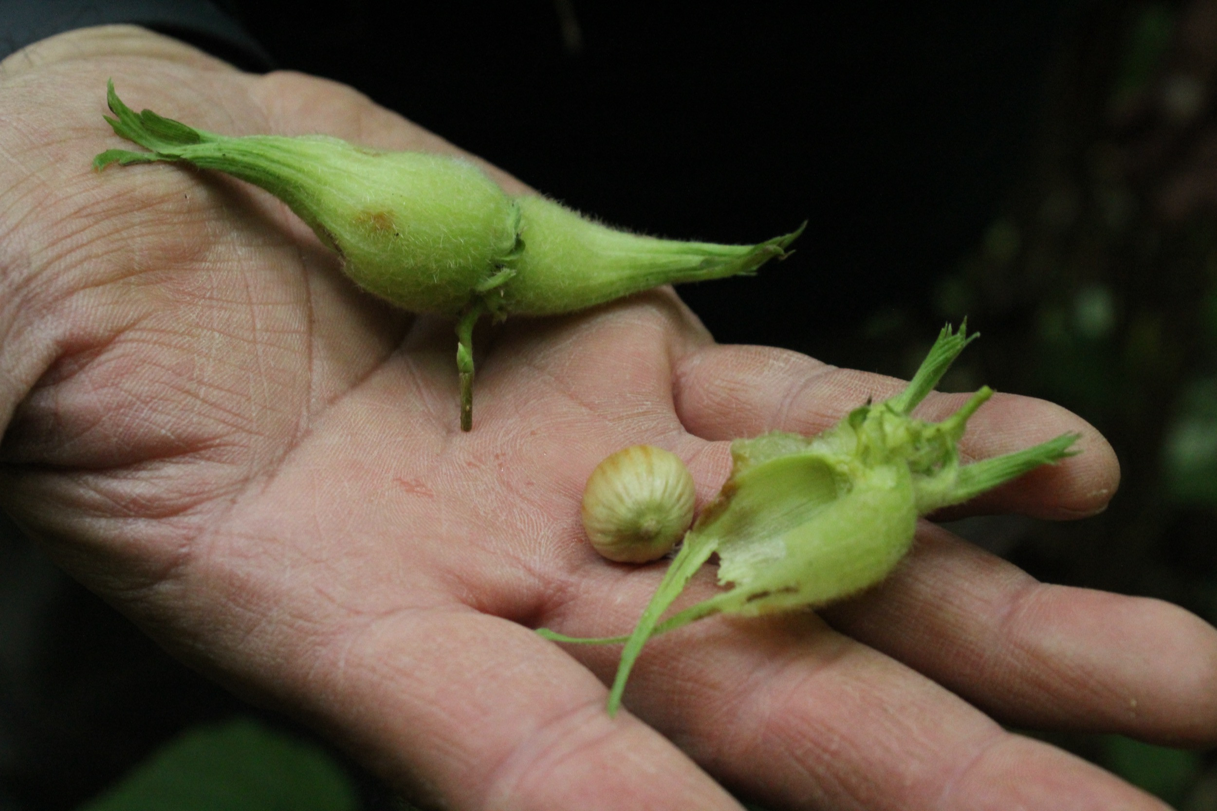
Beaked hazelnut fruit, originating from southern British Columbia, found in Gitselasu villages in the north. Photo courtesy Chelsey Geralda Armstrong

A new study challenges traditional assumptions that pre-colonial Indigenous populations were only “hunter-gatherers” who did not actively manage the landscapes they occupied. Published in the Proceedings of the National Academy of Sciences, the research reveals the profound role of Indigenous peoples in shaping the ecosystems of the Pacific Northwest.

Led by Chelsey Geralda Armstrong (Indigenous Studies, Simon Fraser University) and a team of interdisciplinary scientists from Hakai Institute, the research indicates that Gitxsan, Ts’msyen, and Nisga’a were actively transplanting and managing hazelnut tree populations.

Research Unveils Ancient Indigenous Cultivation of Hazelnut in British Columbia

Chelsey Geralda Armstrong excavating in the ancestral Gwininitxw forest garden. Photo courtesy Chelsey Geralda Armstrong

The study uncovers the deep historical and genetic connections between seemingly isolated hazelnut populations in northwestern British Columbia, highlighting the sophisticated stewardship of these supposedly "wild" plants long before settler colonialism. This is the first genetic evidence showing direct evidence of the management and cultivation of plant species like beaked hazelnut (Corylus cornuta).

This long-distance transplanting and in-situ cultivation of hazelnut demonstrates how Indigenous communities shaped plant species distributions in their territories over time—contradicting previous assumptions that hazelnut was naturally occurring in the region, as well as colonial narratives that view Indigenous land-use practices as passive or even non-existent.

Research Unveils Ancient Indigenous Cultivation of Hazelnut in British Columbia

Darren Bolton (Gitselasu, Ts’msyen) in the Gitsaex hazel orchard. Photo courtesy Chelsey Geralda Armstrong

"For far too long, Indigenous peoples have been discounted as agents and even architects of species range distributions throughout North America,” says Armstrong.

“This is strongly challenged here with not just genetic evidence, but also linguistic, ethnographic, and ethnobotanical evidence. The paper makes a strong case that people were moving favored species throughout their homelands, throughout time."

The research further provides a window into the historical interplay between people and plants, where non-domesticated species like hazelnut were as vital to food, medicine, and technologies as domesticated crops. The findings highlight the importance of recognizing Indigenous knowledge and nuanced impacts of people-plant interactions through time—all of which need to be better articulated and respected in settler conservation and restoration strategies.

About the Study

Research Unveils Ancient Indigenous Cultivation of Hazelnut in British Columbia

Rute Carvalho at the Quadra Island Ecological Observatory’s Marna Genome Lab.

The findings were a result of a fortunate synergy between Armstrong and her collaborators, who had a theory requiring genetic data for confirmation, and Hakai Institute genomics researchers with expertise in population genetics. Based at the Marna Genome Lab on Quadra Island, British Columbia, Hakai Institute researchers oversaw the sample processing and analysis of genomic data.

This research is part of ongoing efforts by Armstong and her collaborators to understand the co-evolutionary relationships between humans and plants in the Pacific Northwest. By integrating genetic data with ethnographic and archaeological records, the team works to uncover the overlooked histories of Indigenous plant management, contributing to a broader understanding of land stewardship practices.

Key Findings

  • Genetic evidence supports long-distance transplanting and cultivation of hazelnut by Indigenous Peoples in British Columbia.

  • The research emphasizes the importance of Indigenous stewardship in shaping plant species' distribution, challenging settler-colonial narratives of "wild" landscapes.

  • Ethnographic and ethnobotanical indices enhance the explanatory power of plant genetic profiles and biogeography and help to uncover the history of culturally important taxa.

For the original media release and photos, click here.

December 6, 2024

Back to Baffin: Tracking Bowheads

Hakai Institute geospatial scientist Keith Holmes traveled to Baffin Island to assist with tagging bowhead whales for data collection.

Back to Baffin: Tracking Bowheads

A temporary suction-cup tag can be seen on a bowhead whale in Cumberland Sound, Baffin Island, Nunavut, Canada. The tag collects video, audio, depth, location, and movement data, providing crucial insights into whale foraging behavior and the ecological dynamics of northern ocean environments.

Sarah Fortune began researching bowhead whales in the fjords around Pangnirtung—a hamlet on Baffin Island, Nunavut—in 2012. Fortune, a Dalhousie assistant professor of oceanography, is studying the potential impacts of climate change on the diets of bowhead whales. Her team includes Inuit biologists and field technicians, physical and chemical oceanographers, marine biologists, and whale ecologists. 

As noted in our article in the last issue of Tula Quarterly, ​​Hakai Institute videographer and drone operator Katrina Pyne joined Fortune’s project for part of the summer of 2023; her drone videos allowed the team to visually track whale behavior, determine age classes, and identify particular individuals. 

This collaboration was extended in the summer of 2024 when Hakai Institute geospatial scientist Keith Holmes joined Fortune’s team in Pangnirtung, providing further drone-operation and data-collection assistance. 

Back to Baffin: Tracking Bowheads

Keith Holmes poses next to the whale-tagging drone “Pang” in Cumberland Sound, Nunavut. Photo by Sarah Fortune

Once again, an arsenal of high-tech gadgets was deployed to gather data from the whales, including 22 tracking tags. A dozen of these were long-term tags that will help provide information on the location and diving behaviors of several bowheads for years to come. 

Although data analysis is still in progress, early findings suggest significant changes in the whales’ environment, including potential displacement of bowheads by killer whales in one region of the study area.

Research and data collection were conducted under DFO Permit 24/25 1021 in collaboration with the Whale Ecology and Conservation Laboratory at Dalhousie University.

December 6, 2024

Ancient Cores from an Ocean Canyon

DNA analysis of sediment cores offers researchers a 14,000-year window into a deep-sea ecosystem.

Ancient Cores from an Ocean Canyon

Hakai Institute researchers Linda Rutledge and Chris Hebda, left and center, examine a sediment core with Cooper Stacey of Natural Resources Canada at the Institute of Ocean Sciences in Sidney, British Columbia.

Taking a sediment core a thousand meters below the surface of the ocean can be a tricky business. But once you have a core, the material contained within it can tell a fascinating story about the inhabitants of ancient ecosystems and environmental change. Researchers are increasingly enthusiastic about examining marine sediment cores to decipher the ways that deep-sea ecosystems have altered over thousands of years.

The critical tool is environmental DNA (eDNA) analysis. This is a non-invasive method that captures DNA from environmental samples—whether seawater, soil, or marine sediment—to detect what organisms were living in the ecosystem. A subset of eDNA is sedimentary ancient DNA (sedaDNA). The sedaDNA approach is now being used to help researchers understand biodiversity shifts in specific ocean locations over time. 

Marine canyons are biodiversity hotspots, where organisms have adapted to the unique conditions of the deep sea. Barkley Canyon, located off the coast of southern Vancouver Island, reaches depths of up to 2,000 meters. The area is a popular destination for deep-sea research due to its steep coral cliffs and rich array of marine life.  

Cooper Stacey, a marine geologist with Natural Resources Canada, has worked to extract marine sediment cores from Barkley Canyon that are as much as two meters in length. Researchers Linda Rutledge and Danielle Grant at the Hakai Institute Ancient DNA Laboratory on Quadra Island are studying some of these cores, enabling them to begin to reconstruct Barkley Canyon ecosystems—all the way back to the Pleistocene-Holocene transition that occurred 11,000–14,000 years ago. 

Ancient Cores from an Ocean Canyon

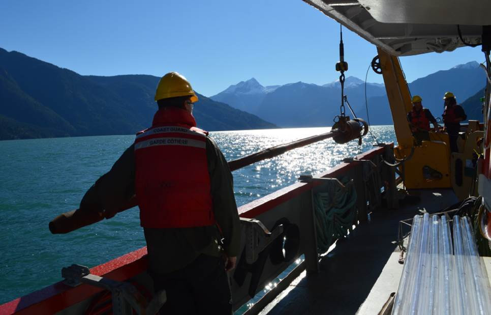
A piston corer used for sediment sampling is deployed by a technician off the Vector, a Canadian Coast Guard hydrographic survey vessel. In Barkley Sound, the core sampling rig is smaller, and known as a gravity corer. Photo courtesy NRCAN

So far they have detected ancient genomic signals for harmful algal blooms (HABs), including a bioluminescent dinoflagellate called a sea sparkle; a type of Pacific jellyfish called sea nettle; bony and cartilaginous fish; and coastal ferns—the latter potentially hinting at a way that terrestrial materials made their way into this deep ocean canyon. 

“Canyons are also of interest to sedaDNA work because they accumulate organic matter from nearby and more distant regions of the ocean, including the shallows,” says Rutledge. “The results can provide a broad view of biodiversity that is not only site-specific.”

One concern for scientists is that certain technologies, such as the use of X-rays, might affect the quality of the DNA they are trying to sequence. X-rays are routinely used in marine geology to assess the density and composition of sediment cores, and Hakai Institute researchers are testing to see whether they impact biodiversity estimates.

If X-rays are found to leave DNA undamaged, that means that the many archived and X-rayed marine sediment cores stored in global repositories could continue to be used for sedaDNA work. Updates coming soon!

December 6, 2024

Tula in the News

Tula in the News

Tula’s Digital Health Project Contributes to Life-Saving Care in Guatemala

In September 2024, Guatemala’s national news outlet Prensa Libre published a story about the quick response by frontline health workers to the condition of a malnourished child. The child, Ada, lives in the remote community of Tucurú, Alta Verapaz, and health workers were able to monitor and respond quickly because she was registered for TulaSalud’s digital health app, Kawok.

Tula in the News

Racing to Understand Sea Star Wasting Disease

The work of Hakai Institute researcher Alyssa Gehman, looking into the causes of sea star wasting disease, was featured in both Canadian Geographic and Vox.

Tula in the News

BC Scientists Measure Snowpack to Predict Water Supply—and How Much is Left

Several times a year, a team of BC scientists treks into the Vancouver Island mountains to collect samples of the snowpack so they can gather data and determine whether the snowpack is declining—and if so, by how much. This data will become crucial in the future to determine how much communities will need to ration water because of climate change.

Tula in the News

Chilcotin River’s Landslide Lake Begins Draining

The threat of flash flooding on the Chilcotin River in British Columbia has subsided following a large landslide on July 30, 2024 that dammed the river. Brian Menounos has been working with the Hakai Institute, using LiDAR to map how the landscape around the landslide site and downriver has changed.

Tula in the News

Unique Ocean Studies Program Brought to Life by Generous Funding

Announced October 24, 2024, the Ocean Frontier Institute (OFI) has partnered with the Marine Institute at Memorial University in Newfoundland and Labrador and the Hakai Institute to launch a prestigious, multidisciplinary and multi-location training program to enhance the ocean-observation skills of 10 early-career scientists from around the world.

Tula in the News

Behind Eric Peterson and Christina Munck’s Final Donation to the Tula Foundation

The couple has been donating their personal funds to the Tula Foundation since they established the charity in 2001. Tula is their legacy, and they want to ensure that its numerous projects will stay afloat for years to come. This might be their last donation, but their work is not over yet.

December 6, 2024

Recent Publications

Bull kelp (Nereocystis luetkeana) growth rates as climate stress indicators for Canada’s Pacific coast. 

Abstract excerpt:

Primary producers’ growth rates are ideal bioindicators of changing climate due to their sensitivity to environmental conditions. On the Central Coast of British Columbia, we assessed growth rates of Nereocystis luetkeana, a canopy-forming annual kelp, by assessing baseline variability in growth rates and their response to environmental conditions of over 600 individuals and across three sites (2016–2019). 

Pontier, O., Rhoades, O., Twist, B., Okamoto, D., & Hessing-Lewis, M. (2024). Facets. doi.org/10.1139/facets-2023-0237

The core microbiome of cultured Pacific oyster spat is affected by age but not mortality.

Abstract excerpt:

The Pacific oyster is the most widely cultured shellfish worldwide, but production has been affected by mortality events, including in hatcheries that supply the seed for growers. Several pathogens cause disease in oysters, but in many cases, mortality events cannot be attributed to a single agent and appear to be multifactorial, involving environmental variables and microbial interactions. 

Cho, A., Finke, J. F., Zhong, K. X., Chan, A. M., Saunders, R., Schulze, A., ... & Suttle, C. A. (2024). Microbiology Spectrum, e00031-24. doi.org/10.1128/spectrum.00031-24

Estimating size-at-harvest from Indigenous archaeological clamshell assemblages in coastal British Columbia.

Abstract excerpt:

Shellfish have supported Indigenous lifeways on the Pacific Coast of North America for millennia. Despite the ubiquity of clamshells in archaeological sites, shell size measurements are rarely reported due to a lack of applicable basis for generating size estimates from fragmentary remains. We present a linear regression-based method for determining shell length from hinge and umbo measurements of littleneck (Leukoma staminea; n = 239), butter (Saxidomus gigantea; n = 274), and horse (Tresus nuttallii; n = 92) clams using both contemporary and archaeological shells collected from three regions in coastal British Columbia, Canada.

Hillis, D., Barclay, K. M., Foster, E., Kobluk, H. M., Vollman, T., Salomon, A. K., Darimon, C.T., & McKechnie, I. (2024). Facets. doi.org/10.1139/facets-2023-0128

Detection differences between eDNA and mid‐water trawls are driven by fish biomass and habitat preferences.

Abstract excerpt:

Marine scientific trawl surveys are commonly used to assess the distribution and population size of fisheries-related species, yet the method is effort-intensive and can be environmentally destructive. Sequencing environmental DNA (eDNA) from water samples can reveal the presence of organisms in a community without capturing them; however, we expect the detectability of taxa to differ between eDNA and trawl surveys, and understanding how species traits and population variables contribute to detection differences can help calibrate our expectations from each form of sampling.

Rehill, T., Millard‐Martin, B., Lemay, M., Sheridan, K., Mueller, A., Morien, E., Clemente-Carvalho, R& Sunday, J. M. (2024). Environmental DNA, 6(4), e586. doi.org/10.1002/edn3.586

Source and variation of the amazing live sea monkey microbiome. 

Abstract excerpt:

An embryonic diapause in unfavourable conditions has allowed brine shrimp to thrive in hypersaline environments and, unexpectedly, mail-order sachets and small, novelty tanks. Marketed as Sea-Monkeys®, each kit involves a three-step process to generate adult Artemia within a matter of weeks. Whether these kits also allow for the maintenance of a host-associated microbiome is unclear…. Overall, Sea-Monkeys® kits appear to be a convenient and scalable mesocosm for the study of host-microbiome interactions and could serve as a useful tool for future invertebrate microbiome research, outreach, and education.

Holt, C. C., del Campo, J., & Keeling, P. J. (2024). Source and variation of the amazing live sea monkey microbiome. Plos One, 19(8), e0308763. doi.org/10.1371/journal.pone.0308763

Phylogenomic diversity of archigregarine apicomplexans. 

Abstract excerpt:

Gregarines are a large and diverse subgroup of Apicomplexa, a lineage of obligate animal symbionts including pathogens such as Plasmodium, the malaria parasite. Unlike Plasmodium, however, gregarines are poorly studied, despite the fact that as early-branching apicomplexans they are crucial to our understanding of the origin and evolution of all apicomplexans and their parasitic lifestyle.  

Lax, G., Park, E., Na, I., Jacko-Reynolds, V., Kwong, W. K., House, C. S., Trznadel, M., Wakeman, K., Leander, B.S., & Keeling, P. (2024). Open Biology, 14(9), 240141. doi.org/10.1098/rsob.240141

Mapping phenoregions and phytoplankton seasonality in Northeast Pacific marine coastal ecosystems via a satellite-based approach. 

Abstract excerpt:

Phytoplankton phenology describes yearly algal growth cycles and characterizes the timing, duration, and magnitude of bloom occurrences. This study used satellite chlorophyll-a data from 1998 to 2020 and the Hierarchical Agglomerative Clustering method to define phenoregions based on phytoplankton phenology spatial patterns over the British Columbia and Southeast Alaska coastal oceans. The defined phenoregions were used to simplify the spatial complexity of the heterogenous study region and thus better describe phytoplankton seasonality across the target area. 

Pramlall, S., Jackson, J. M., Marchese, C., Suchy, K. D., Hunt, B. P., & Costa, M. (2024). Progress in Oceanography, 103336. doi.org/10.1016/j.pocean.2024.103336

Molecular phylogeny of the Lecudinoidea (Apicomplexa): A major group of marine gregarines with diverse shapes, movements and hosts.

Abstract excerpt:

Gregarine apicomplexans are ubiquitous endosymbionts of invertebrate hosts. Despite their ecological and evolutionary importance, inferences about the phylogenetic relationships of major gregarine groups, such as the Lecudinidae and Urosporidae, have been hindered by vague taxonomic definitions and limited molecular and morphological data. In this study, we investigated five gregarine species collected from four families of polychaete hosts (Nereididae, Oenonidae, Hesionidae, and Phyllodocidae) using light microscopy (LM) and scanning electron microscopy (SEM).

Park, E., & Leander, B. S. The Journal of Eukaryotic Microbiology, e13053. doi.org/10.1111/jeu.13053

Marine microturbellarians from Japan, with descriptions of two new species of Reinhardorhynchus (Platyhelminthes, Rhabdocoela, Koinocystididae).

Abstract excerpt:

Marine microturbellarians are an assemblage of meiofaunal flatworms abundant in sediments and on seaweeds around the world. The diversity and distribution of these animals in Japan are poorly understood. Here, we provide an overview of all recorded species in Japan and characterize two new species of the rhabdocoela genus Reinhardorhynchus based on morphological features and a molecular phylogeny inferred from 18S and 28S rDNA sequences.

Tsuyuki, A., Reyes, J., Oya, Y., Wakeman, K. C., Leander, B. S., & Van Steenkiste, N. W. (2024). Zoosystematics and Evolution, 100(3), 877-895. doi.org/10.3897/zse.100.120244